You are here: Home > Network List > TA - USArray Transportable Network (new EarthScope stations) Stations List
> Station F04D Rainier, OR, USA > Earthquake Result Viewer
F04D Rainier, OR, USA - Earthquake Result Viewer
| Earthquake location: |
Solomon Islands |
| Earthquake latitude/longitude: |
-6.7/154.9 |
| Earthquake time(UTC): |
2014/04/19 (109) 13:27:59 GMT |
| Earthquake Depth: |
31 km |
| Earthquake Magnitude: |
7.5 MWW, 7.8 MI |
| Earthquake Catalog/Contributor: |
NEIC PDE/NEIC COMCAT |
|
| Network: |
TA USArray Transportable Network (new EarthScope stations) |
| Station: |
F04D Rainier, OR, USA |
| Lat/Lon: |
46.08 N/123.01 W |
| Elevation: |
236 m |
|
| Distance: |
89.3 deg |
| Az: |
43.583 deg |
| Baz: |
259.661 deg |
| Ray Param: |
0.04190696 |
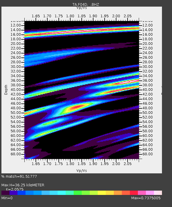
| Estimated Moho Depth: |
36.25 km |
| Estimated Crust Vp/Vs: |
2.06 |
| Assumed Crust Vp: |
6.566 km/s |
| Estimated Crust Vs: |
3.191 km/s |
| Estimated Crust Poisson's Ratio: |
0.35 |
|
| Radial Match: |
91.51777 % |
| Radial Bump: |
400 |
| Transverse Match: |
73.81698 % |
| Transverse Bump: |
400 |
| SOD ConfigId: |
626651 |
| Insert Time: |
2014-05-03 14:01:09.327 +0000 |
| GWidth: |
2.5 |
| Max Bumps: |
400 |
| Tol: |
0.001 |
|

Signal To Noise
| Channel | StoN | STA | LTA |
| TA:F04D: :BHZ:20140419T13:40:21.400024Z | 7.445549 | 3.39152E-6 | 4.5550976E-7 |
| TA:F04D: :BHN:20140419T13:40:21.400024Z | 0.587627 | 4.163095E-7 | 7.0845874E-7 |
| TA:F04D: :BHE:20140419T13:40:21.400024Z | 2.034338 | 1.1421985E-6 | 5.6145956E-7 |
| Arrivals |
| Ps | 5.9 SECOND |
| PpPs | 17 SECOND |
| PsPs/PpSs | 23 SECOND |


