You are here: Home > Network List > US - United States National Seismic Network Stations List
> Station WVOR Wild Horse Valley, Oregon, USA > Earthquake Result Viewer
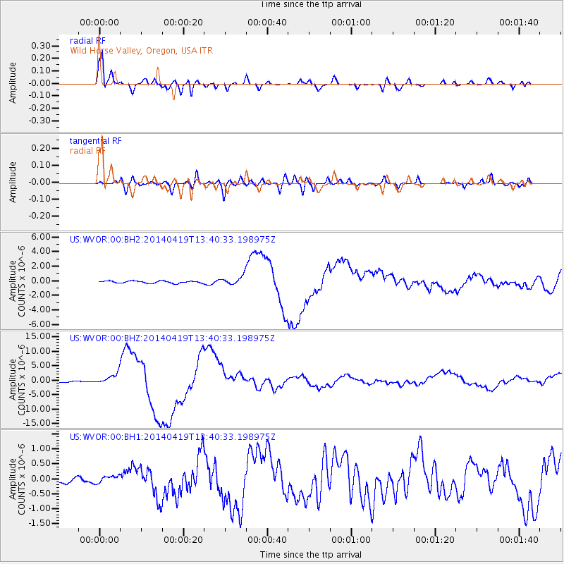
WVOR Wild Horse Valley, Oregon, USA - Earthquake Result Viewer
| Earthquake location: |
Solomon Islands |
| Earthquake latitude/longitude: |
-6.7/154.9 |
| Earthquake time(UTC): |
2014/04/19 (109) 13:27:59 GMT |
| Earthquake Depth: |
31 km |
| Earthquake Magnitude: |
7.5 MWW, 7.8 MI |
| Earthquake Catalog/Contributor: |
NEIC PDE/NEIC COMCAT |
|
| Network: |
US United States National Seismic Network |
| Station: |
WVOR Wild Horse Valley, Oregon, USA |
| Lat/Lon: |
42.43 N/118.64 W |
| Elevation: |
1344 m |
|
| Distance: |
91.9 deg |
| Az: |
47.668 deg |
| Baz: |
262.664 deg |
| Ray Param: |
0.041538775 |
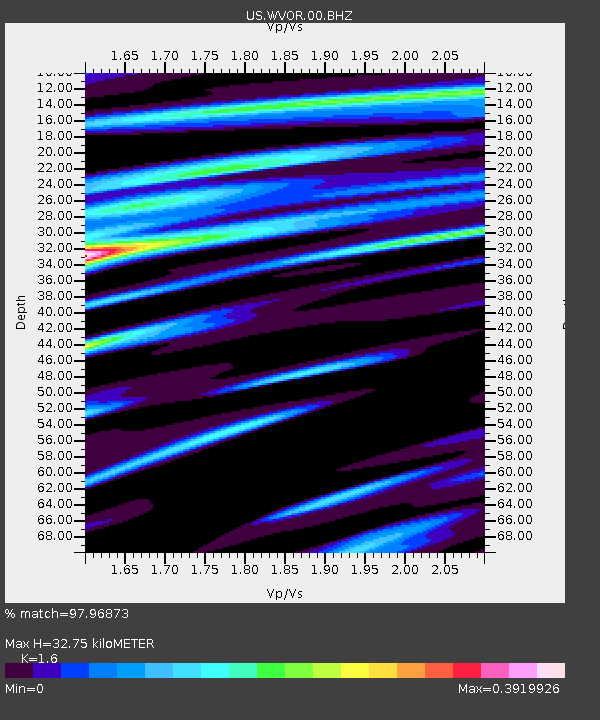
| Estimated Moho Depth: |
32.75 km |
| Estimated Crust Vp/Vs: |
1.60 |
| Assumed Crust Vp: |
6.279 km/s |
| Estimated Crust Vs: |
3.924 km/s |
| Estimated Crust Poisson's Ratio: |
0.18 |
|
| Radial Match: |
97.96873 % |
| Radial Bump: |
400 |
| Transverse Match: |
88.89544 % |
| Transverse Bump: |
400 |
| SOD ConfigId: |
626651 |
| Insert Time: |
2014-05-03 14:04:55.064 +0000 |
| GWidth: |
2.5 |
| Max Bumps: |
400 |
| Tol: |
0.001 |
|
Signal To Noise
| Channel | StoN | STA | LTA |
| US:WVOR:00:BHZ:20140419T13:40:33.198975Z | 8.2941675 | 1.9235924E-6 | 2.3192109E-7 |
| US:WVOR:00:BH1:20140419T13:40:33.198975Z | 1.2364217 | 1.2411073E-7 | 1.0037897E-7 |
| US:WVOR:00:BH2:20140419T13:40:33.198975Z | 3.9941375 | 6.129771E-7 | 1.5346919E-7 |
| Arrivals |
| Ps | 3.2 SECOND |
| PpPs | 13 SECOND |
| PsPs/PpSs | 16 SECOND |


