You are here: Home > Network List > UW - Pacific Northwest Regional Seismic Network Stations List
> Station LON Longmire (broad-band and DWWSSN) > Earthquake Result Viewer
LON Longmire (broad-band and DWWSSN) - Earthquake Result Viewer
| Earthquake location: |
Solomon Islands |
| Earthquake latitude/longitude: |
-6.7/154.9 |
| Earthquake time(UTC): |
2014/04/19 (109) 13:27:59 GMT |
| Earthquake Depth: |
31 km |
| Earthquake Magnitude: |
7.5 MWW, 7.8 MI |
| Earthquake Catalog/Contributor: |
NEIC PDE/NEIC COMCAT |
|
| Network: |
UW Pacific Northwest Regional Seismic Network |
| Station: |
LON Longmire (broad-band and DWWSSN) |
| Lat/Lon: |
46.75 N/121.81 W |
| Elevation: |
850 m |
|
| Distance: |
90.2 deg |
| Az: |
43.069 deg |
| Baz: |
260.526 deg |
| Ray Param: |
0.041683726 |
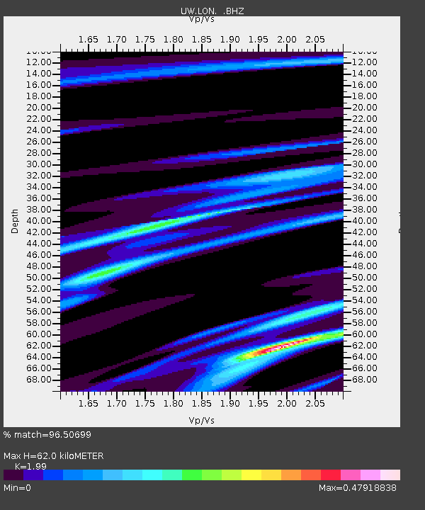
| Estimated Moho Depth: |
62.0 km |
| Estimated Crust Vp/Vs: |
1.99 |
| Assumed Crust Vp: |
6.597 km/s |
| Estimated Crust Vs: |
3.315 km/s |
| Estimated Crust Poisson's Ratio: |
0.33 |
|
| Radial Match: |
96.50699 % |
| Radial Bump: |
296 |
| Transverse Match: |
83.369705 % |
| Transverse Bump: |
400 |
| SOD ConfigId: |
626651 |
| Insert Time: |
2014-05-03 14:07:31.870 +0000 |
| GWidth: |
2.5 |
| Max Bumps: |
400 |
| Tol: |
0.001 |
|
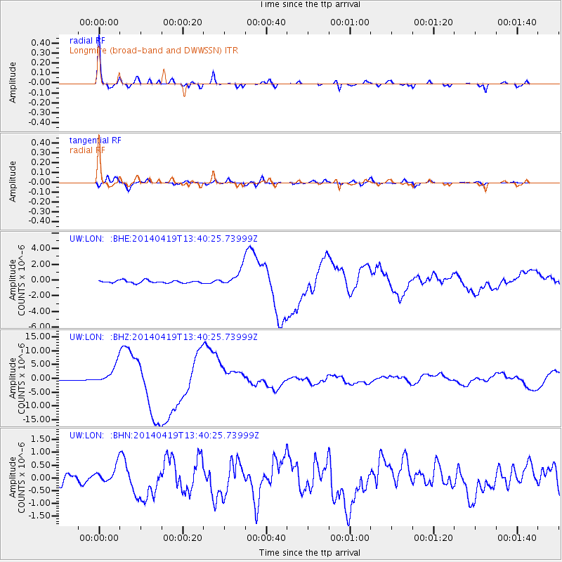
Signal To Noise
| Channel | StoN | STA | LTA |
| UW:LON: :BHZ:20140419T13:40:25.73999Z | 22.648066 | 3.7622253E-6 | 1.6611685E-7 |
| UW:LON: :BHN:20140419T13:40:25.73999Z | 2.176347 | 3.497019E-7 | 1.6068299E-7 |
| UW:LON: :BHE:20140419T13:40:25.73999Z | 7.222091 | 1.1718685E-6 | 1.6226166E-7 |
| Arrivals |
| Ps | 9.5 SECOND |
| PpPs | 28 SECOND |
| PsPs/PpSs | 37 SECOND |


