You are here: Home > Network List > YN10 - San Jacinto Fault Zone Stations List
> Station JFS2 JFS2 > Earthquake Result Viewer
JFS2 JFS2 - Earthquake Result Viewer
| Earthquake location: |
Solomon Islands |
| Earthquake latitude/longitude: |
-6.7/154.9 |
| Earthquake time(UTC): |
2014/04/19 (109) 13:27:59 GMT |
| Earthquake Depth: |
31 km |
| Earthquake Magnitude: |
7.5 MWW, 7.8 MI |
| Earthquake Catalog/Contributor: |
NEIC PDE/NEIC COMCAT |
|
| Network: |
YN San Jacinto Fault Zone |
| Station: |
JFS2 JFS2 |
| Lat/Lon: |
33.42 N/116.40 W |
| Elevation: |
645 m |
|
| Distance: |
92.5 deg |
| Az: |
56.816 deg |
| Baz: |
263.684 deg |
| Ray Param: |
0.04142755 |
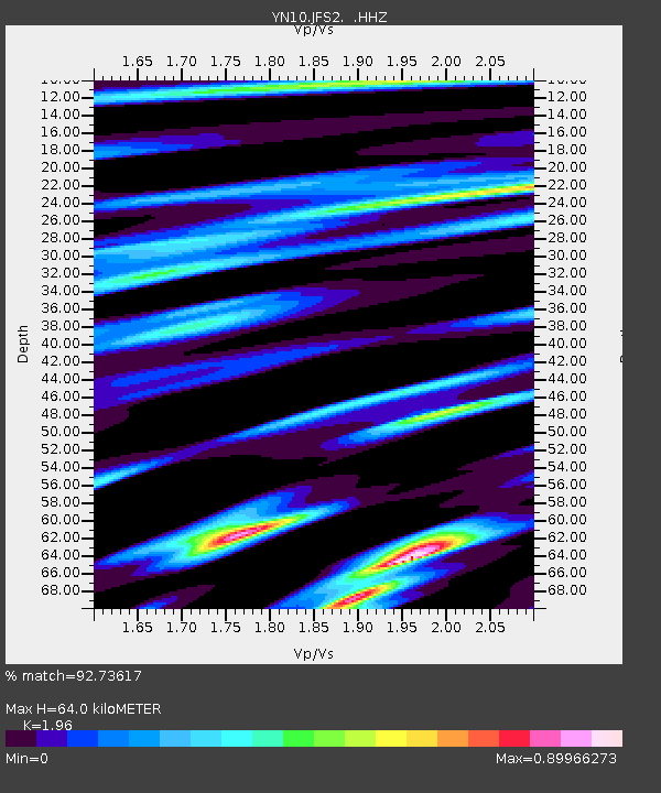
| Estimated Moho Depth: |
64.0 km |
| Estimated Crust Vp/Vs: |
1.96 |
| Assumed Crust Vp: |
6.264 km/s |
| Estimated Crust Vs: |
3.196 km/s |
| Estimated Crust Poisson's Ratio: |
0.32 |
|
| Radial Match: |
92.73617 % |
| Radial Bump: |
400 |
| Transverse Match: |
86.766685 % |
| Transverse Bump: |
400 |
| SOD ConfigId: |
626651 |
| Insert Time: |
2014-05-03 14:10:00.241 +0000 |
| GWidth: |
2.5 |
| Max Bumps: |
400 |
| Tol: |
0.001 |
|

Signal To Noise
| Channel | StoN | STA | LTA |
| YN:JFS2: :HHZ:20140419T13:40:36.348999Z | 4.4808593 | 9.497706E-7 | 2.119617E-7 |
| YN:JFS2: :HHN:20140419T13:40:36.348999Z | 1.028314 | 2.0091089E-7 | 1.9537893E-7 |
| YN:JFS2: :HHE:20140419T13:40:36.348999Z | 1.2072748 | 5.0331937E-7 | 4.169054E-7 |
| Arrivals |
| Ps | 10.0 SECOND |
| PpPs | 30 SECOND |
| PsPs/PpSs | 40 SECOND |


