You are here: Home > Network List > G - GEOSCOPE Stations List
> Station TAOE Taiohae, Marquises islands > Earthquake Result Viewer
TAOE Taiohae, Marquises islands - Earthquake Result Viewer
| Earthquake location: |
Solomon Islands |
| Earthquake latitude/longitude: |
-7.1/154.7 |
| Earthquake time(UTC): |
2014/04/19 (109) 13:47:51 GMT |
| Earthquake Depth: |
72 km |
| Earthquake Magnitude: |
5.6 MB |
| Earthquake Catalog/Contributor: |
NEIC PDE/NEIC COMCAT |
|
| Network: |
G GEOSCOPE |
| Station: |
TAOE Taiohae, Marquises islands |
| Lat/Lon: |
8.85 S/140.15 W |
| Elevation: |
800 m |
|
| Distance: |
64.4 deg |
| Az: |
96.411 deg |
| Baz: |
266.347 deg |
| Ray Param: |
0.058741573 |
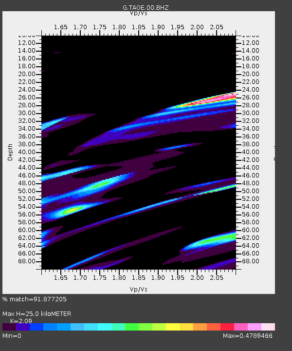
| Estimated Moho Depth: |
25.0 km |
| Estimated Crust Vp/Vs: |
2.09 |
| Assumed Crust Vp: |
4.24 km/s |
| Estimated Crust Vs: |
2.029 km/s |
| Estimated Crust Poisson's Ratio: |
0.35 |
|
| Radial Match: |
91.877205 % |
| Radial Bump: |
400 |
| Transverse Match: |
47.693245 % |
| Transverse Bump: |
387 |
| SOD ConfigId: |
626651 |
| Insert Time: |
2014-05-03 14:17:53.668 +0000 |
| GWidth: |
2.5 |
| Max Bumps: |
400 |
| Tol: |
0.001 |
|
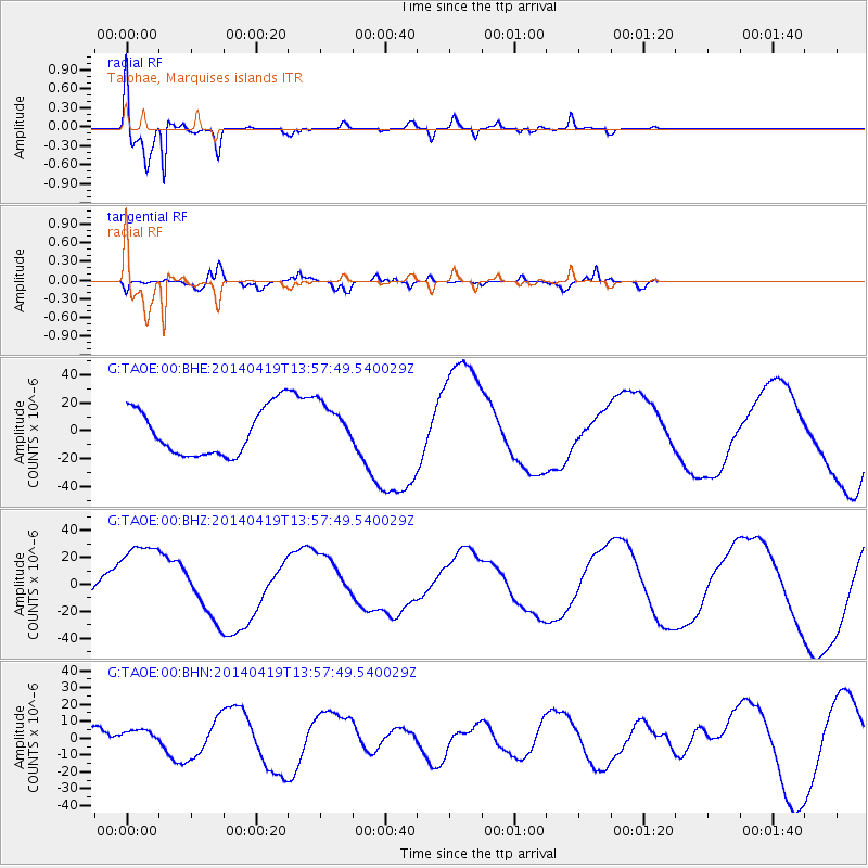
Signal To Noise
| Channel | StoN | STA | LTA |
| G:TAOE:00:BHZ:20140419T13:57:49.540029Z | 1.947377 | 3.0073254E-5 | 1.5442954E-5 |
| G:TAOE:00:BHN:20140419T13:57:49.540029Z | 0.5460002 | 4.9143673E-6 | 9.00067E-6 |
| G:TAOE:00:BHE:20140419T13:57:49.540029Z | 1.0674647 | 1.780109E-5 | 1.6676046E-5 |
| Arrivals |
| Ps | 6.5 SECOND |
| PpPs | 18 SECOND |
| PsPs/PpSs | 24 SECOND |


