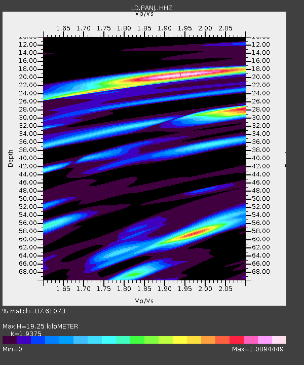
PANJ Princeton, NJ - Earthquake Result Viewer

Earthquake location: Northern Mid-Atlantic Ridge
Earthquake latitude/longitude: 52.6/-31.9
Earthquake time(UTC): 2015/02/13 (044) 18:59:12 GMT
Earthquake Depth: 16 km
Earthquake Magnitude: 7.1 MWW, 6.8 MI, 7.0 MWB, 7.0 MWC, 7.1 MWC
Earthquake Catalog/Contributor: NEIC PDE/NEIC COMCAT
Network: LD Lamont-Doherty Cooperative Seismographic Network
Station: PANJ Princeton, NJ
Lat/Lon: 40.38 N/74.70 W
Elevation: 100 m
Distance: 31.4 deg
Az: 264.392 deg
Baz: 52.558 deg
Ray Param: 0.07905865
Estimated Moho Depth: 19.25 km
Estimated Crust Vp/Vs: 1.94
Assumed Crust Vp: 6.283 km/s
Estimated Crust Vs: 3.243 km/s
Estimated Crust Poisson's Ratio: 0.32
Radial Match: 87.61073 %
Radial Bump: 301
Transverse Match: 46.503975 %
Transverse Bump: 371
SOD ConfigId: 7019011
Insert Time: 2019-04-16 19:26:30.117 +0000
GWidth: 2.5
Max Bumps: 400
Tol: 0.001

Signal To Noise

ChannelStoNSTALTA
LD:PANJ: :HHZ:20150213T19:05:02.477991Z2.10987831.3202983E-66.257699E-7
LD:PANJ: :HHN:20150213T19:05:02.477991Z1.65657468.3952966E-75.0678653E-7
LD:PANJ: :HHE:20150213T19:05:02.477991Z1.74910471.2982468E-67.4223504E-7
Arrivals
Ps3.1 SECOND
PpPs8.4 SECOND
PsPs/PpSs11 SECOND