You are here: Home > Network List > TA - USArray Transportable Network (new EarthScope stations) Stations List
> Station K46A Dorr, MI, USA > Earthquake Result Viewer
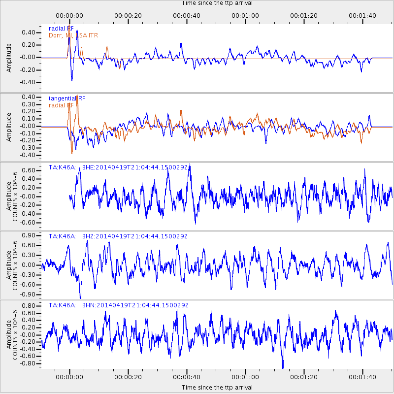
K46A Dorr, MI, USA - Earthquake Result Viewer
*The percent match for this event was below the threshold and hence no stack was calculated.
| Earthquake location: |
Near Coast Of Northern Chile |
| Earthquake latitude/longitude: |
-20.0/-70.9 |
| Earthquake time(UTC): |
2014/04/19 (109) 20:54:42 GMT |
| Earthquake Depth: |
9.0 km |
| Earthquake Magnitude: |
5.8 MWR |
| Earthquake Catalog/Contributor: |
NEIC PDE/NEIC COMCAT |
|
| Network: |
TA USArray Transportable Network (new EarthScope stations) |
| Station: |
K46A Dorr, MI, USA |
| Lat/Lon: |
42.69 N/85.78 W |
| Elevation: |
213 m |
|
| Distance: |
63.9 deg |
| Az: |
347.834 deg |
| Baz: |
164.41 deg |
| Ray Param: |
$rayparam |
*The percent match for this event was below the threshold and hence was not used in the summary stack. |
|
| Radial Match: |
58.61873 % |
| Radial Bump: |
400 |
| Transverse Match: |
58.302357 % |
| Transverse Bump: |
400 |
| SOD ConfigId: |
626651 |
| Insert Time: |
2014-05-03 21:34:21.090 +0000 |
| GWidth: |
2.5 |
| Max Bumps: |
400 |
| Tol: |
0.001 |
|
Signal To Noise
| Channel | StoN | STA | LTA |
| TA:K46A: :BHZ:20140419T21:04:44.150029Z | 2.4781744 | 4.3884518E-7 | 1.7708406E-7 |
| TA:K46A: :BHN:20140419T21:04:44.150029Z | 0.8235803 | 1.869241E-7 | 2.2696524E-7 |
| TA:K46A: :BHE:20140419T21:04:44.150029Z | 1.5504186 | 3.005878E-7 | 1.9387525E-7 |
| Arrivals |
| Ps | |
| PpPs | |
| PsPs/PpSs | |


