You are here: Home > Network List > TA - USArray Transportable Network (new EarthScope stations) Stations List
> Station N48A Decatur, IN, USA > Earthquake Result Viewer
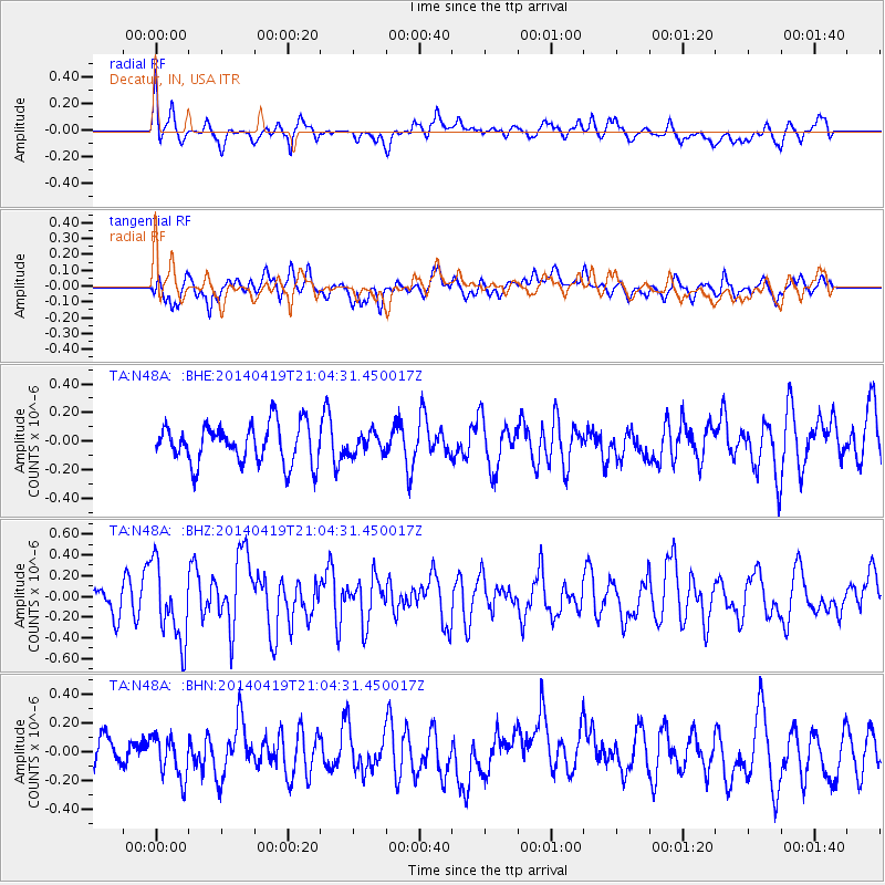
N48A Decatur, IN, USA - Earthquake Result Viewer
*The percent match for this event was below the threshold and hence no stack was calculated.
| Earthquake location: |
Near Coast Of Northern Chile |
| Earthquake latitude/longitude: |
-20.0/-70.9 |
| Earthquake time(UTC): |
2014/04/19 (109) 20:54:42 GMT |
| Earthquake Depth: |
9.0 km |
| Earthquake Magnitude: |
5.8 MWR |
| Earthquake Catalog/Contributor: |
NEIC PDE/NEIC COMCAT |
|
| Network: |
TA USArray Transportable Network (new EarthScope stations) |
| Station: |
N48A Decatur, IN, USA |
| Lat/Lon: |
40.86 N/85.03 W |
| Elevation: |
250 m |
|
| Distance: |
62.0 deg |
| Az: |
347.905 deg |
| Baz: |
164.944 deg |
| Ray Param: |
$rayparam |
*The percent match for this event was below the threshold and hence was not used in the summary stack. |
|
| Radial Match: |
55.625942 % |
| Radial Bump: |
400 |
| Transverse Match: |
52.80802 % |
| Transverse Bump: |
400 |
| SOD ConfigId: |
626651 |
| Insert Time: |
2014-05-03 21:36:36.262 +0000 |
| GWidth: |
2.5 |
| Max Bumps: |
400 |
| Tol: |
0.001 |
|
Signal To Noise
| Channel | StoN | STA | LTA |
| TA:N48A: :BHZ:20140419T21:04:31.450017Z | 2.7080948 | 3.6690264E-7 | 1.3548367E-7 |
| TA:N48A: :BHN:20140419T21:04:31.450017Z | 0.8523398 | 1.4925898E-7 | 1.7511675E-7 |
| TA:N48A: :BHE:20140419T21:04:31.450017Z | 0.5179475 | 7.104215E-8 | 1.3716091E-7 |
| Arrivals |
| Ps | |
| PpPs | |
| PsPs/PpSs | |


