You are here: Home > Network List > N4 - Central and EAstern US Network Stations List
> Station T59A Double 'B' Farms, VA, USA > Earthquake Result Viewer
T59A Double 'B' Farms, VA, USA - Earthquake Result Viewer
| Earthquake location: |
Northern Mid-Atlantic Ridge |
| Earthquake latitude/longitude: |
52.6/-31.9 |
| Earthquake time(UTC): |
2015/02/13 (044) 18:59:12 GMT |
| Earthquake Depth: |
16 km |
| Earthquake Magnitude: |
7.1 MWW, 6.8 MI, 7.0 MWB, 7.0 MWC, 7.1 MWC |
| Earthquake Catalog/Contributor: |
NEIC PDE/NEIC COMCAT |
|
| Network: |
N4 Central and EAstern US Network |
| Station: |
T59A Double 'B' Farms, VA, USA |
| Lat/Lon: |
36.97 N/77.55 W |
| Elevation: |
63 m |
|
| Distance: |
35.3 deg |
| Az: |
262.176 deg |
| Baz: |
48.93 deg |
| Ray Param: |
0.07726604 |
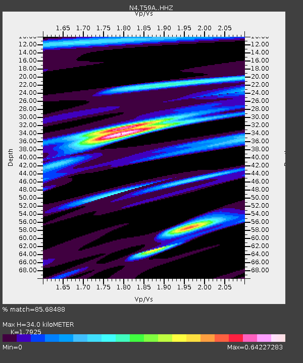
| Estimated Moho Depth: |
34.0 km |
| Estimated Crust Vp/Vs: |
1.79 |
| Assumed Crust Vp: |
6.565 km/s |
| Estimated Crust Vs: |
3.662 km/s |
| Estimated Crust Poisson's Ratio: |
0.27 |
|
| Radial Match: |
85.68488 % |
| Radial Bump: |
244 |
| Transverse Match: |
58.105278 % |
| Transverse Bump: |
356 |
| SOD ConfigId: |
7019011 |
| Insert Time: |
2019-04-16 19:27:25.636 +0000 |
| GWidth: |
2.5 |
| Max Bumps: |
400 |
| Tol: |
0.001 |
|

Signal To Noise
| Channel | StoN | STA | LTA |
| N4:T59A: :HHZ:20150213T19:05:36.159998Z | 1.0496833 | 6.287557E-7 | 5.9899554E-7 |
| N4:T59A: :HHN:20150213T19:05:36.159998Z | 0.70897985 | 3.820348E-7 | 5.3885145E-7 |
| N4:T59A: :HHE:20150213T19:05:36.159998Z | 1.4934666 | 6.086879E-7 | 4.0756714E-7 |
| Arrivals |
| Ps | 4.4 SECOND |
| PpPs | 13 SECOND |
| PsPs/PpSs | 18 SECOND |


