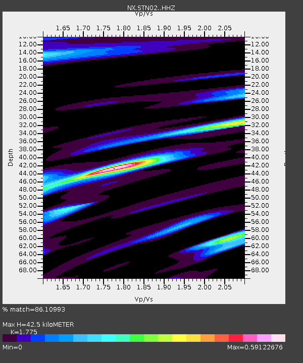
STN02 Seismic station 02 - Earthquake Result Viewer

Earthquake location: Northern Mid-Atlantic Ridge
Earthquake latitude/longitude: 52.6/-31.9
Earthquake time(UTC): 2015/02/13 (044) 18:59:12 GMT
Earthquake Depth: 16 km
Earthquake Magnitude: 7.1 MWW, 6.8 MI, 7.0 MWB, 7.0 MWC, 7.1 MWC
Earthquake Catalog/Contributor: NEIC PDE/NEIC COMCAT
Network: NX Nanometrics Research Network
Station: STN02 Seismic station 02
Lat/Lon: 35.95 N/97.51 W
Elevation: 342 m
Distance: 48.1 deg
Az: 276.998 deg
Baz: 48.205 deg
Ray Param: 0.06954255
Estimated Moho Depth: 42.5 km
Estimated Crust Vp/Vs: 1.77
Assumed Crust Vp: 6.426 km/s
Estimated Crust Vs: 3.62 km/s
Estimated Crust Poisson's Ratio: 0.27
Radial Match: 86.10993 %
Radial Bump: 322
Transverse Match: 47.218105 %
Transverse Bump: 332
SOD ConfigId: 7019011
Insert Time: 2019-04-16 19:28:05.404 +0000
GWidth: 2.5
Max Bumps: 400
Tol: 0.001

Signal To Noise

ChannelStoNSTALTA
NX:STN02: :HHZ:20150213T19:07:20.980005Z2.63674471.1760585E-64.460267E-7
NX:STN02: :HH1:20150213T19:07:20.980005Z1.06278285.899448E-75.5509446E-7
NX:STN02: :HH2:20150213T19:07:20.980005Z1.82878181.1829364E-66.4684394E-7
Arrivals
Ps5.4 SECOND
PpPs17 SECOND
PsPs/PpSs23 SECOND