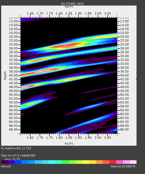
STN05 Z - Earthquake Result Viewer

Earthquake location: Northern Mid-Atlantic Ridge
Earthquake latitude/longitude: 52.6/-31.9
Earthquake time(UTC): 2015/02/13 (044) 18:59:12 GMT
Earthquake Depth: 16 km
Earthquake Magnitude: 7.1 MWW, 6.8 MI, 7.0 MWB, 7.0 MWC, 7.1 MWC
Earthquake Catalog/Contributor: NEIC PDE/NEIC COMCAT
Network: NX Nanometrics Research Network
Station: STN05 Z
Lat/Lon: 35.85 N/96.64 W
Elevation: 285 m
Distance: 47.7 deg
Az: 276.266 deg
Baz: 48.217 deg
Ray Param: 0.069824226
Estimated Moho Depth: 37.5 km
Estimated Crust Vp/Vs: 1.72
Assumed Crust Vp: 6.426 km/s
Estimated Crust Vs: 3.742 km/s
Estimated Crust Poisson's Ratio: 0.24
Radial Match: 84.11753 %
Radial Bump: 294
Transverse Match: 61.120674 %
Transverse Bump: 400
SOD ConfigId: 7019011
Insert Time: 2019-04-16 19:28:06.450 +0000
GWidth: 2.5
Max Bumps: 400
Tol: 0.001

Signal To Noise

ChannelStoNSTALTA
NX:STN05: :HHZ:20150213T19:07:17.469995Z2.14869121.4017503E-66.5237407E-7
NX:STN05: :HH1:20150213T19:07:17.469995Z1.32543067.143702E-75.3897213E-7
NX:STN05: :HH2:20150213T19:07:17.469995Z1.25878739.2019246E-77.3101506E-7
Arrivals
Ps4.5 SECOND
PpPs15 SECOND
PsPs/PpSs19 SECOND