You are here: Home > Network List > IU - Global Seismograph Network (GSN - IRIS/USGS) Stations List
> Station RAR Rarotonga, Cook Islands > Earthquake Result Viewer
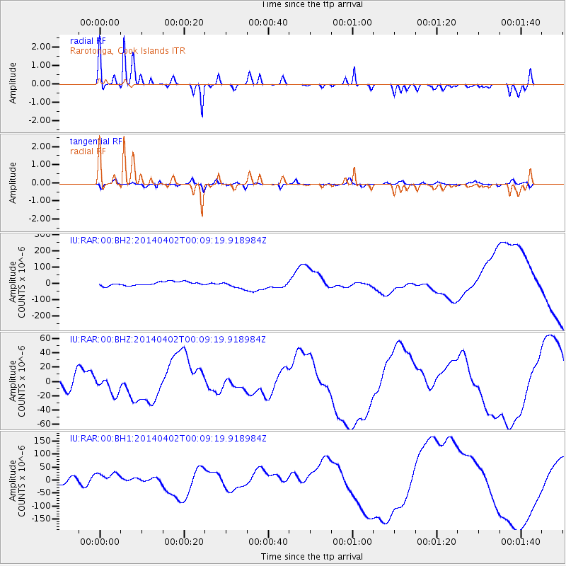
RAR Rarotonga, Cook Islands - Earthquake Result Viewer

| Earthquake location: |
Near Coast Of Northern Chile |
| Earthquake latitude/longitude: |
-20.0/-70.6 |
| Earthquake time(UTC): |
2014/04/01 (091) 23:57:33 GMT |
| Earthquake Depth: |
35 km |
| Earthquake Magnitude: |
6.9 MWW, 4.9 MB |
| Earthquake Catalog/Contributor: |
NEIC PDE/NEIC COMCAT |
|
| Network: |
IU Global Seismograph Network (GSN - IRIS/USGS) |
| Station: |
RAR Rarotonga, Cook Islands |
| Lat/Lon: |
21.21 S/159.77 W |
| Elevation: |
28 m |
|
| Distance: |
82.3 deg |
| Az: |
250.311 deg |
| Baz: |
108.422 deg |
| Ray Param: |
0.0469578 |
| Estimated Moho Depth: |
24.25 km |
| Estimated Crust Vp/Vs: |
2.01 |
| Assumed Crust Vp: |
4.24 km/s |
| Estimated Crust Vs: |
2.115 km/s |
| Estimated Crust Poisson's Ratio: |
0.33 |
|
| Radial Match: |
83.04869 % |
| Radial Bump: |
388 |
| Transverse Match: |
67.812065 % |
| Transverse Bump: |
400 |
| SOD ConfigId: |
626651 |
| Insert Time: |
2014-05-03 23:01:39.374 +0000 |
| GWidth: |
2.5 |
| Max Bumps: |
400 |
| Tol: |
0.001 |
|
Signal To Noise
| Channel | StoN | STA | LTA |
| IU:RAR:00:BHZ:20140402T00:09:19.918984Z | 1.1303868 | 1.1933932E-5 | 1.0557387E-5 |
| IU:RAR:00:BH1:20140402T00:09:19.918984Z | 1.984817 | 2.3721816E-5 | 1.1951639E-5 |
| IU:RAR:00:BH2:20140402T00:09:19.918984Z | 1.960862 | 2.2764343E-5 | 1.1609355E-5 |
| Arrivals |
| Ps | 5.8 SECOND |
| PpPs | 17 SECOND |
| PsPs/PpSs | 23 SECOND |


