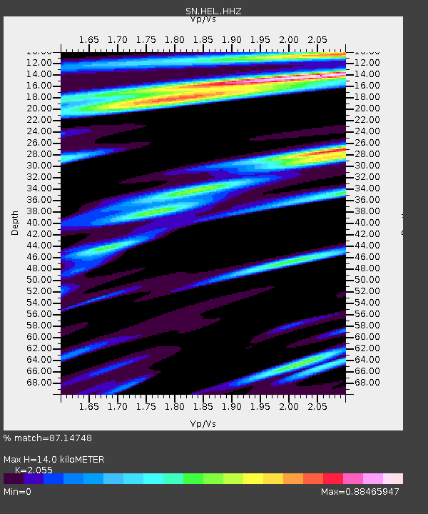
HEL Hell's Gate, California w84 - Earthquake Result Viewer

Earthquake location: Northern Mid-Atlantic Ridge
Earthquake latitude/longitude: 52.6/-31.9
Earthquake time(UTC): 2015/02/13 (044) 18:59:12 GMT
Earthquake Depth: 16 km
Earthquake Magnitude: 7.1 MWW, 6.8 MI, 7.0 MWB, 7.0 MWC, 7.1 MWC
Earthquake Catalog/Contributor: NEIC PDE/NEIC COMCAT
Network: SN Southern Great Basin Network
Station: HEL Hell's Gate, California w84
Lat/Lon: 36.72 N/116.98 W
Elevation: 747 m
Distance: 59.1 deg
Az: 291.068 deg
Baz: 45.061 deg
Ray Param: 0.06241426
Estimated Moho Depth: 14.0 km
Estimated Crust Vp/Vs: 2.06
Assumed Crust Vp: 6.279 km/s
Estimated Crust Vs: 3.055 km/s
Estimated Crust Poisson's Ratio: 0.34
Radial Match: 87.14748 %
Radial Bump: 370
Transverse Match: 70.40092 %
Transverse Bump: 400
SOD ConfigId: 7019011
Insert Time: 2019-04-16 19:29:27.241 +0000
GWidth: 2.5
Max Bumps: 400
Tol: 0.001

Signal To Noise

ChannelStoNSTALTA
SN:HEL: :HHZ:20150213T19:08:41.397974Z3.99637066.0733004E-71.519704E-7
SN:HEL: :HHN:20150213T19:08:41.397974Z0.77991272.637861E-73.3822516E-7
SN:HEL: :HHE:20150213T19:08:41.397974Z1.29655771.8601898E-71.4347144E-7
Arrivals
Ps2.4 SECOND
PpPs6.5 SECOND
PsPs/PpSs9.0 SECOND