You are here: Home > Network List > TA - USArray Transportable Network (new EarthScope stations) Stations List
> Station H17A Grant Village (NPS), Yellowstone Nt. Park, WY, USA > Earthquake Result Viewer
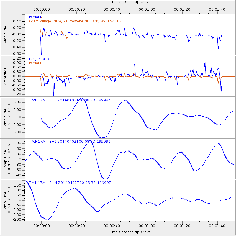
H17A Grant Village (NPS), Yellowstone Nt. Park, WY, USA - Earthquake Result Viewer
*The percent match for this event was below the threshold and hence no stack was calculated.
| Earthquake location: |
Near Coast Of Northern Chile |
| Earthquake latitude/longitude: |
-20.0/-70.6 |
| Earthquake time(UTC): |
2014/04/01 (091) 23:57:33 GMT |
| Earthquake Depth: |
35 km |
| Earthquake Magnitude: |
6.9 MWW, 4.9 MB |
| Earthquake Catalog/Contributor: |
NEIC PDE/NEIC COMCAT |
|
| Network: |
TA USArray Transportable Network (new EarthScope stations) |
| Station: |
H17A Grant Village (NPS), Yellowstone Nt. Park, WY, USA |
| Lat/Lon: |
44.40 N/110.58 W |
| Elevation: |
2400 m |
|
| Distance: |
73.8 deg |
| Az: |
331.316 deg |
| Baz: |
140.986 deg |
| Ray Param: |
$rayparam |
*The percent match for this event was below the threshold and hence was not used in the summary stack. |
|
| Radial Match: |
59.330376 % |
| Radial Bump: |
361 |
| Transverse Match: |
48.891884 % |
| Transverse Bump: |
306 |
| SOD ConfigId: |
626651 |
| Insert Time: |
2014-05-03 23:10:47.717 +0000 |
| GWidth: |
2.5 |
| Max Bumps: |
400 |
| Tol: |
0.001 |
|
Signal To Noise
| Channel | StoN | STA | LTA |
| TA:H17A: :BHZ:20140402T00:08:33.19999Z | 0.27230397 | 6.824141E-6 | 2.5060748E-5 |
| TA:H17A: :BHN:20140402T00:08:33.19999Z | 1.4228556 | 2.0377531E-4 | 1.4321573E-4 |
| TA:H17A: :BHE:20140402T00:08:33.19999Z | 1.8112855 | 2.4048833E-4 | 1.3277218E-4 |
| Arrivals |
| Ps | |
| PpPs | |
| PsPs/PpSs | |


