You are here: Home > Network List > TA - USArray Transportable Network (new EarthScope stations) Stations List
> Station U59A Littleton, NC, USA > Earthquake Result Viewer
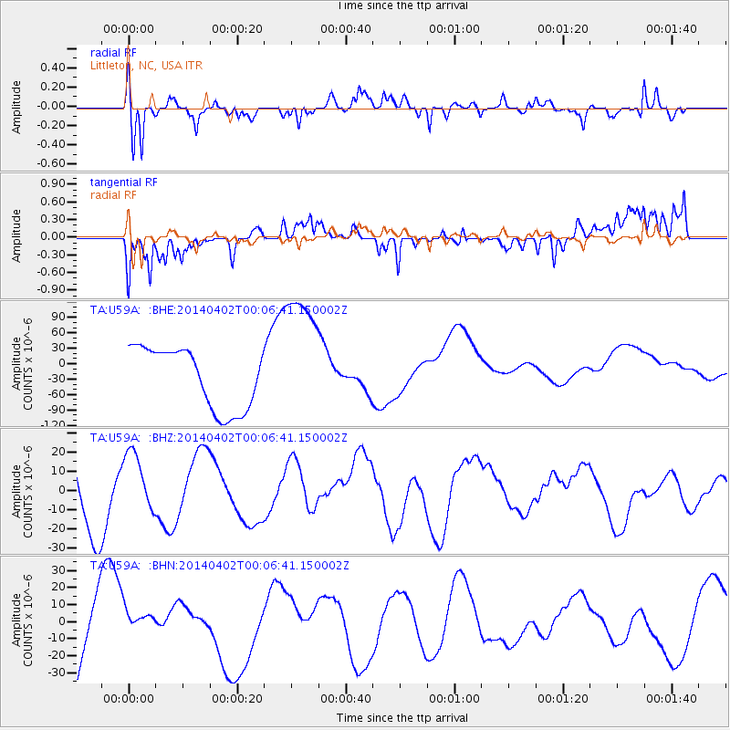
U59A Littleton, NC, USA - Earthquake Result Viewer
*The percent match for this event was below the threshold and hence no stack was calculated.
| Earthquake location: |
Near Coast Of Northern Chile |
| Earthquake latitude/longitude: |
-20.0/-70.6 |
| Earthquake time(UTC): |
2014/04/01 (091) 23:57:33 GMT |
| Earthquake Depth: |
35 km |
| Earthquake Magnitude: |
6.9 MWW, 4.9 MB |
| Earthquake Catalog/Contributor: |
NEIC PDE/NEIC COMCAT |
|
| Network: |
TA USArray Transportable Network (new EarthScope stations) |
| Station: |
U59A Littleton, NC, USA |
| Lat/Lon: |
36.35 N/77.79 W |
| Elevation: |
99 m |
|
| Distance: |
56.5 deg |
| Az: |
352.999 deg |
| Baz: |
171.839 deg |
| Ray Param: |
$rayparam |
*The percent match for this event was below the threshold and hence was not used in the summary stack. |
|
| Radial Match: |
63.32423 % |
| Radial Bump: |
400 |
| Transverse Match: |
22.663525 % |
| Transverse Bump: |
292 |
| SOD ConfigId: |
626651 |
| Insert Time: |
2014-05-03 23:17:01.275 +0000 |
| GWidth: |
2.5 |
| Max Bumps: |
400 |
| Tol: |
0.001 |
|
Signal To Noise
| Channel | StoN | STA | LTA |
| TA:U59A: :BHZ:20140402T00:06:41.150002Z | 0.73377323 | 1.5694704E-5 | 2.138904E-5 |
| TA:U59A: :BHN:20140402T00:06:41.150002Z | 0.33820933 | 7.979334E-6 | 2.3592886E-5 |
| TA:U59A: :BHE:20140402T00:06:41.150002Z | 2.2319252 | 1.3161225E-4 | 5.896804E-5 |
| Arrivals |
| Ps | |
| PpPs | |
| PsPs/PpSs | |


