You are here: Home > Network List > TA - USArray Transportable Network (new EarthScope stations) Stations List
> Station P58A Pank, Wackersville, MD, USA > Earthquake Result Viewer
P58A Pank, Wackersville, MD, USA - Earthquake Result Viewer
| Earthquake location: |
Northern Mid-Atlantic Ridge |
| Earthquake latitude/longitude: |
52.6/-31.9 |
| Earthquake time(UTC): |
2015/02/13 (044) 18:59:12 GMT |
| Earthquake Depth: |
16 km |
| Earthquake Magnitude: |
7.1 MWW, 6.8 MI, 7.0 MWB, 7.0 MWC, 7.1 MWC |
| Earthquake Catalog/Contributor: |
NEIC PDE/NEIC COMCAT |
|
| Network: |
TA USArray Transportable Network (new EarthScope stations) |
| Station: |
P58A Pank, Wackersville, MD, USA |
| Lat/Lon: |
39.49 N/77.30 W |
| Elevation: |
139 m |
|
| Distance: |
33.6 deg |
| Az: |
265.371 deg |
| Baz: |
51.722 deg |
| Ray Param: |
0.07813325 |
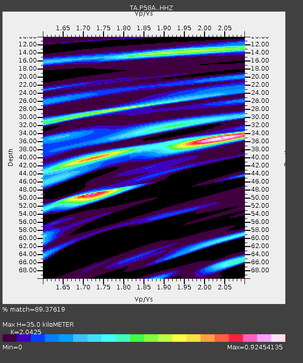
| Estimated Moho Depth: |
35.0 km |
| Estimated Crust Vp/Vs: |
2.04 |
| Assumed Crust Vp: |
6.419 km/s |
| Estimated Crust Vs: |
3.143 km/s |
| Estimated Crust Poisson's Ratio: |
0.34 |
|
| Radial Match: |
89.37619 % |
| Radial Bump: |
354 |
| Transverse Match: |
54.060677 % |
| Transverse Bump: |
400 |
| SOD ConfigId: |
7019011 |
| Insert Time: |
2019-04-16 19:30:17.527 +0000 |
| GWidth: |
2.5 |
| Max Bumps: |
400 |
| Tol: |
0.001 |
|

Signal To Noise
| Channel | StoN | STA | LTA |
| TA:P58A: :HHZ:20150213T19:05:21.020013Z | 1.0724404 | 1.128184E-6 | 1.0519782E-6 |
| TA:P58A: :HHN:20150213T19:05:21.020013Z | 1.1458241 | 1.3682787E-6 | 1.1941438E-6 |
| TA:P58A: :HHE:20150213T19:05:21.020013Z | 1.2764761 | 1.1587416E-6 | 9.07766E-7 |
| Arrivals |
| Ps | 6.1 SECOND |
| PpPs | 16 SECOND |
| PsPs/PpSs | 22 SECOND |


