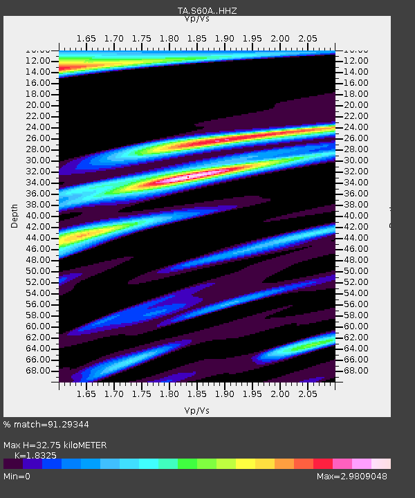
S60A Water View, VA, USA - Earthquake Result Viewer
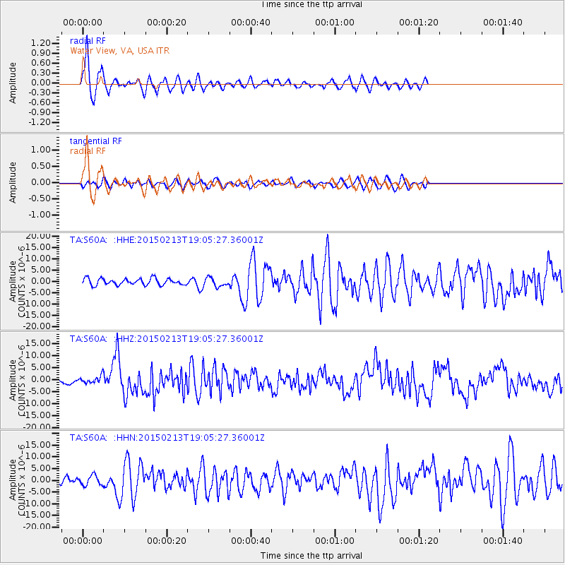
Earthquake location: Northern Mid-Atlantic Ridge
Earthquake latitude/longitude: 52.6/-31.9
Earthquake time(UTC): 2015/02/13 (044) 18:59:12 GMT
Earthquake Depth: 16 km
Earthquake Magnitude: 7.1 MWW, 6.8 MI, 7.0 MWB, 7.0 MWC, 7.1 MWC
Earthquake Catalog/Contributor: NEIC PDE/NEIC COMCAT
Network: TA USArray Transportable Network (new EarthScope stations)
Station: S60A Water View, VA, USA
Lat/Lon: 37.42 N/76.39 W
Elevation: 36 m
Distance: 34.3 deg
Az: 261.709 deg
Baz: 49.246 deg
Ray Param: 0.077781156
Estimated Moho Depth: 32.75 km
Estimated Crust Vp/Vs: 1.83
Assumed Crust Vp: 6.565 km/s
Estimated Crust Vs: 3.582 km/s
Estimated Crust Poisson's Ratio: 0.29
Radial Match: 91.29344 %
Radial Bump: 397
Transverse Match: 65.43596 %
Transverse Bump: 400
SOD ConfigId: 7019011
Insert Time: 2019-04-16 19:30:26.443 +0000
GWidth: 2.5
Max Bumps: 400
Tol: 0.001

Signal To Noise

ChannelStoNSTALTA
TA:S60A: :HHZ:20150213T19:05:27.36001Z2.6345851.5864026E-66.021452E-7
TA:S60A: :HHN:20150213T19:05:27.36001Z1.29043462.1201326E-61.6429602E-6
TA:S60A: :HHE:20150213T19:05:27.36001Z1.40912391.979195E-61.4045572E-6
Arrivals
Ps4.5 SECOND
PpPs13 SECOND
PsPs/PpSs18 SECOND