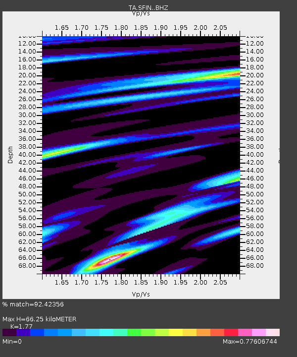
SFIN Lafayette, IN, USA - Earthquake Result Viewer

Earthquake location: Northern Mid-Atlantic Ridge
Earthquake latitude/longitude: 52.6/-31.9
Earthquake time(UTC): 2015/02/13 (044) 18:59:12 GMT
Earthquake Depth: 16 km
Earthquake Magnitude: 7.1 MWW, 6.8 MI, 7.0 MWB, 7.0 MWC, 7.1 MWC
Earthquake Catalog/Contributor: NEIC PDE/NEIC COMCAT
Network: TA USArray Transportable Network (new EarthScope stations)
Station: SFIN Lafayette, IN, USA
Lat/Lon: 40.38 N/87.10 W
Elevation: 165 m
Distance: 39.0 deg
Az: 274.353 deg
Baz: 52.703 deg
Ray Param: 0.075226
Estimated Moho Depth: 66.25 km
Estimated Crust Vp/Vs: 1.77
Assumed Crust Vp: 6.498 km/s
Estimated Crust Vs: 3.671 km/s
Estimated Crust Poisson's Ratio: 0.27
Radial Match: 92.42356 %
Radial Bump: 325
Transverse Match: 55.06756 %
Transverse Bump: 400
SOD ConfigId: 7019011
Insert Time: 2019-04-16 19:30:26.432 +0000
GWidth: 2.5
Max Bumps: 400
Tol: 0.001

Signal To Noise

ChannelStoNSTALTA
TA:SFIN: :BHZ:20150213T19:06:07.450006Z2.0580689.258415E-74.4985956E-7
TA:SFIN: :BHN:20150213T19:06:07.450006Z0.861927157.354629E-78.532773E-7
TA:SFIN: :BHE:20150213T19:06:07.450006Z2.06281648.947028E-74.3372876E-7
Arrivals
Ps8.5 SECOND
PpPs26 SECOND
PsPs/PpSs35 SECOND