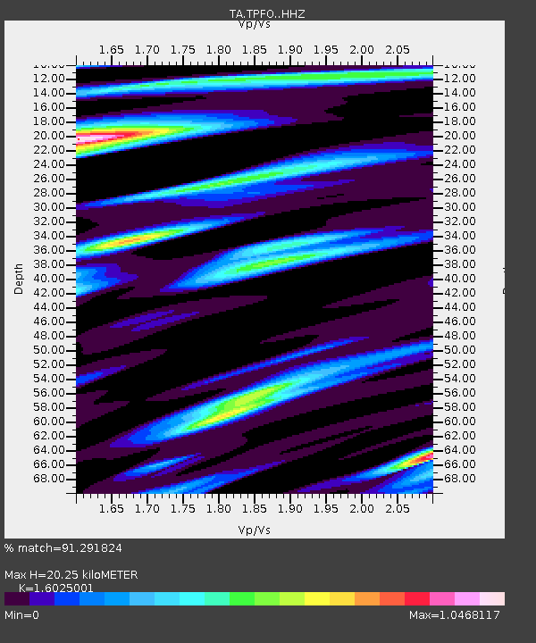
TPFO Pinon Flats, CA, USA - Earthquake Result Viewer
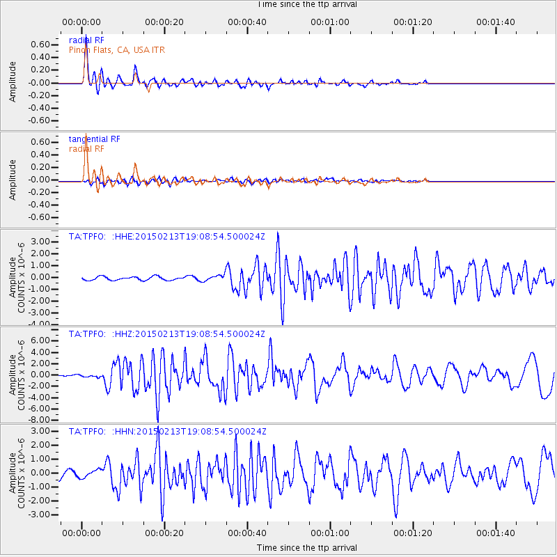
Earthquake location: Northern Mid-Atlantic Ridge
Earthquake latitude/longitude: 52.6/-31.9
Earthquake time(UTC): 2015/02/13 (044) 18:59:12 GMT
Earthquake Depth: 16 km
Earthquake Magnitude: 7.1 MWW, 6.8 MI, 7.0 MWB, 7.0 MWC, 7.1 MWC
Earthquake Catalog/Contributor: NEIC PDE/NEIC COMCAT
Network: TA USArray Transportable Network (new EarthScope stations)
Station: TPFO Pinon Flats, CA, USA
Lat/Lon: 33.61 N/116.45 W
Elevation: 1275 m
Distance: 61.0 deg
Az: 288.199 deg
Baz: 43.927 deg
Ray Param: 0.061149813
Estimated Moho Depth: 20.25 km
Estimated Crust Vp/Vs: 1.60
Assumed Crust Vp: 6.264 km/s
Estimated Crust Vs: 3.909 km/s
Estimated Crust Poisson's Ratio: 0.18
Radial Match: 91.291824 %
Radial Bump: 400
Transverse Match: 71.621475 %
Transverse Bump: 400
SOD ConfigId: 7019011
Insert Time: 2019-04-16 19:30:32.460 +0000
GWidth: 2.5
Max Bumps: 400
Tol: 0.001

Signal To Noise

ChannelStoNSTALTA
TA:TPFO: :HHZ:20150213T19:08:54.500024Z0.770355052.089358E-72.7122013E-7
TA:TPFO: :HHN:20150213T19:08:54.500024Z1.19065992.932861E-72.4632232E-7
TA:TPFO: :HHE:20150213T19:08:54.500024Z1.39381462.1368957E-71.5331278E-7
Arrivals
Ps2.0 SECOND
PpPs8.0 SECOND
PsPs/PpSs10 SECOND