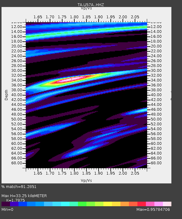
U57A Blanch, NC, USA - Earthquake Result Viewer

Earthquake location: Northern Mid-Atlantic Ridge
Earthquake latitude/longitude: 52.6/-31.9
Earthquake time(UTC): 2015/02/13 (044) 18:59:12 GMT
Earthquake Depth: 16 km
Earthquake Magnitude: 7.1 MWW, 6.8 MI, 7.0 MWB, 7.0 MWC, 7.1 MWC
Earthquake Catalog/Contributor: NEIC PDE/NEIC COMCAT
Network: TA USArray Transportable Network (new EarthScope stations)
Station: U57A Blanch, NC, USA
Lat/Lon: 36.43 N/79.34 W
Elevation: 178 m
Distance: 36.8 deg
Az: 263.092 deg
Baz: 48.61 deg
Ray Param: 0.07648896
Estimated Moho Depth: 33.25 km
Estimated Crust Vp/Vs: 1.79
Assumed Crust Vp: 6.419 km/s
Estimated Crust Vs: 3.591 km/s
Estimated Crust Poisson's Ratio: 0.27
Radial Match: 91.2851 %
Radial Bump: 359
Transverse Match: 78.98867 %
Transverse Bump: 400
SOD ConfigId: 7019011
Insert Time: 2019-04-16 19:30:34.631 +0000
GWidth: 2.5
Max Bumps: 400
Tol: 0.001

Signal To Noise

ChannelStoNSTALTA
TA:U57A: :HHZ:20150213T19:05:48.420007Z1.47692315.194935E-73.5174037E-7
TA:U57A: :HHN:20150213T19:05:48.420007Z2.19111946.7099364E-73.0623326E-7
TA:U57A: :HHE:20150213T19:05:48.420007Z1.03112974.696349E-74.5545667E-7
Arrivals
Ps4.4 SECOND
PpPs13 SECOND
PsPs/PpSs18 SECOND