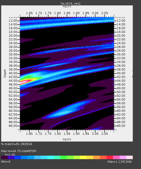
V57A Coltrane Farms, NC, USA - Earthquake Result Viewer

Earthquake location: Northern Mid-Atlantic Ridge
Earthquake latitude/longitude: 52.6/-31.9
Earthquake time(UTC): 2015/02/13 (044) 18:59:12 GMT
Earthquake Depth: 16 km
Earthquake Magnitude: 7.1 MWW, 6.8 MI, 7.0 MWB, 7.0 MWC, 7.1 MWC
Earthquake Catalog/Contributor: NEIC PDE/NEIC COMCAT
Network: TA USArray Transportable Network (new EarthScope stations)
Station: V57A Coltrane Farms, NC, USA
Lat/Lon: 35.89 N/79.78 W
Elevation: 223 m
Distance: 37.4 deg
Az: 262.81 deg
Baz: 48.128 deg
Ray Param: 0.076147646
Estimated Moho Depth: 44.75 km
Estimated Crust Vp/Vs: 1.61
Assumed Crust Vp: 6.565 km/s
Estimated Crust Vs: 4.077 km/s
Estimated Crust Poisson's Ratio: 0.19
Radial Match: 91.092834 %
Radial Bump: 186
Transverse Match: 81.318245 %
Transverse Bump: 400
SOD ConfigId: 7019011
Insert Time: 2019-04-16 19:30:36.049 +0000
GWidth: 2.5
Max Bumps: 400
Tol: 0.001

Signal To Noise

ChannelStoNSTALTA
TA:V57A: :HHZ:20150213T19:05:53.730005Z1.30914455.5344816E-74.227556E-7
TA:V57A: :HHN:20150213T19:05:53.730005Z0.539913652.8878603E-75.3487446E-7
TA:V57A: :HHE:20150213T19:05:53.730005Z1.54992525.45657E-73.5205372E-7
Arrivals
Ps4.5 SECOND
PpPs16 SECOND
PsPs/PpSs21 SECOND