You are here: Home > Network List > TA - USArray Transportable Network (new EarthScope stations) Stations List
> Station X43A Marvell, AR, USA > Earthquake Result Viewer
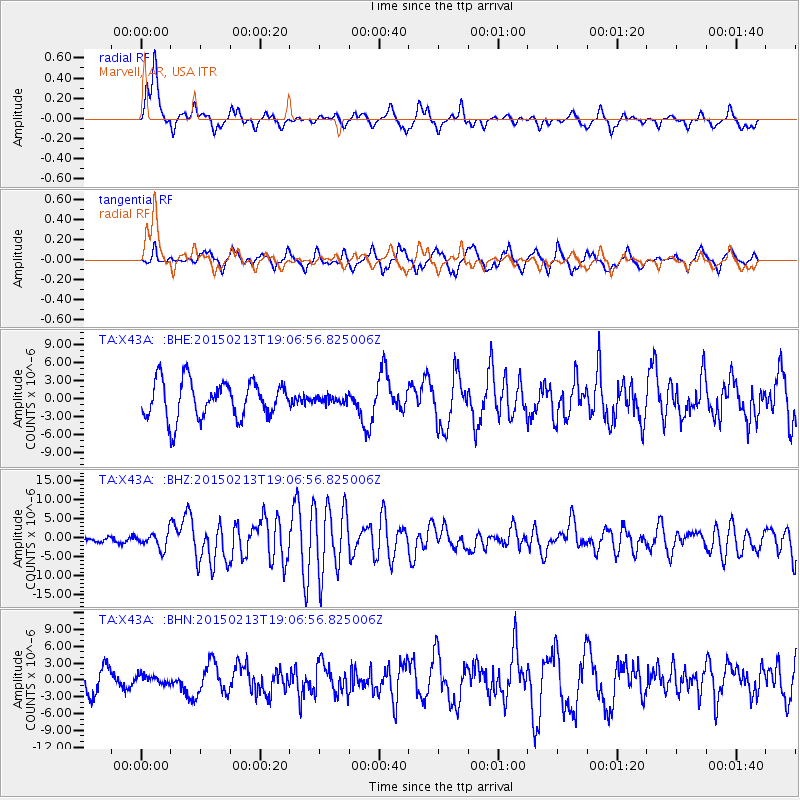
X43A Marvell, AR, USA - Earthquake Result Viewer
*The percent match for this event was below the threshold and hence no stack was calculated.
| Earthquake location: |
Northern Mid-Atlantic Ridge |
| Earthquake latitude/longitude: |
52.6/-31.9 |
| Earthquake time(UTC): |
2015/02/13 (044) 18:59:12 GMT |
| Earthquake Depth: |
16 km |
| Earthquake Magnitude: |
7.1 MWW, 6.8 MI, 7.0 MWB, 7.0 MWC, 7.1 MWC |
| Earthquake Catalog/Contributor: |
NEIC PDE/NEIC COMCAT |
|
| Network: |
TA USArray Transportable Network (new EarthScope stations) |
| Station: |
X43A Marvell, AR, USA |
| Lat/Lon: |
34.52 N/90.88 W |
| Elevation: |
53 m |
|
| Distance: |
45.1 deg |
| Az: |
270.534 deg |
| Baz: |
47.567 deg |
| Ray Param: |
$rayparam |
*The percent match for this event was below the threshold and hence was not used in the summary stack. |
|
| Radial Match: |
71.4695 % |
| Radial Bump: |
317 |
| Transverse Match: |
65.78331 % |
| Transverse Bump: |
377 |
| SOD ConfigId: |
7019011 |
| Insert Time: |
2019-04-16 19:30:43.499 +0000 |
| GWidth: |
2.5 |
| Max Bumps: |
400 |
| Tol: |
0.001 |
|
Signal To Noise
| Channel | StoN | STA | LTA |
| TA:X43A: :BHZ:20150213T19:06:56.825006Z | 2.6358032 | 2.132721E-6 | 8.091351E-7 |
| TA:X43A: :BHN:20150213T19:06:56.825006Z | 0.23472843 | 7.6682215E-7 | 3.2668481E-6 |
| TA:X43A: :BHE:20150213T19:06:56.825006Z | 0.16388136 | 5.111511E-7 | 3.1190314E-6 |
| Arrivals |
| Ps | |
| PpPs | |
| PsPs/PpSs | |


