You are here: Home > Network List > US - United States National Seismic Network Stations List
> Station WVOR Wild Horse Valley, Oregon, USA > Earthquake Result Viewer
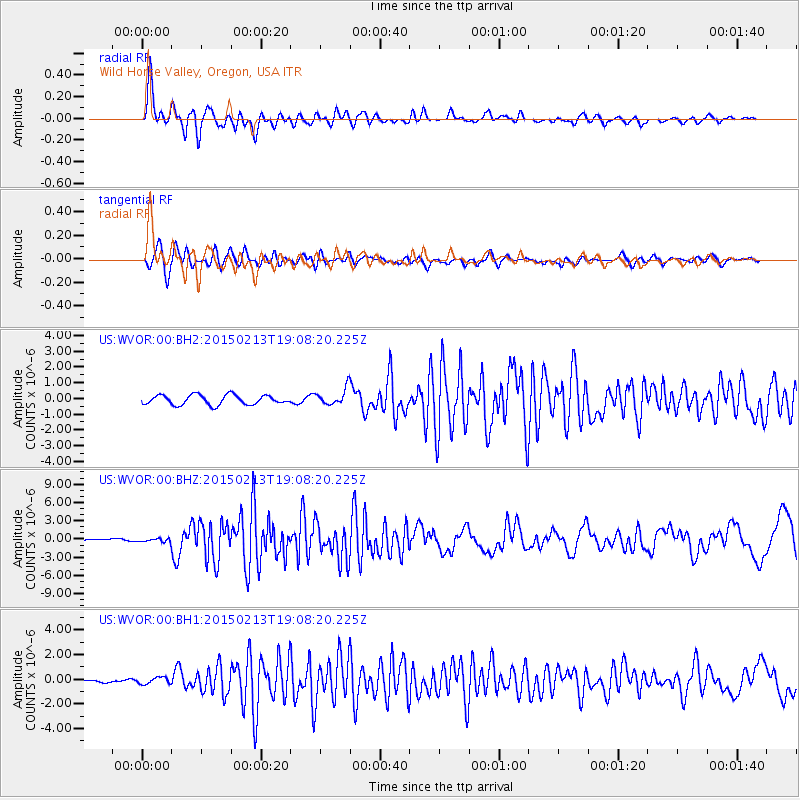
WVOR Wild Horse Valley, Oregon, USA - Earthquake Result Viewer
*The percent match for this event was below the threshold and hence no stack was calculated.
| Earthquake location: |
Northern Mid-Atlantic Ridge |
| Earthquake latitude/longitude: |
52.6/-31.9 |
| Earthquake time(UTC): |
2015/02/13 (044) 18:59:12 GMT |
| Earthquake Depth: |
16 km |
| Earthquake Magnitude: |
7.1 MWW, 6.8 MI, 7.0 MWB, 7.0 MWC, 7.1 MWC |
| Earthquake Catalog/Contributor: |
NEIC PDE/NEIC COMCAT |
|
| Network: |
US United States National Seismic Network |
| Station: |
WVOR Wild Horse Valley, Oregon, USA |
| Lat/Lon: |
42.43 N/118.64 W |
| Elevation: |
1344 m |
|
| Distance: |
56.0 deg |
| Az: |
296.992 deg |
| Baz: |
47.187 deg |
| Ray Param: |
$rayparam |
*The percent match for this event was below the threshold and hence was not used in the summary stack. |
|
| Radial Match: |
90.91405 % |
| Radial Bump: |
400 |
| Transverse Match: |
83.19742 % |
| Transverse Bump: |
400 |
| SOD ConfigId: |
7019011 |
| Insert Time: |
2019-04-16 19:31:34.242 +0000 |
| GWidth: |
2.5 |
| Max Bumps: |
400 |
| Tol: |
0.001 |
|
Signal To Noise
| Channel | StoN | STA | LTA |
| US:WVOR:00:BHZ:20150213T19:08:20.225Z | 1.9730332 | 2.6245465E-7 | 1.330209E-7 |
| US:WVOR:00:BH1:20150213T19:08:20.225Z | 1.1404182 | 2.6597658E-7 | 2.3322723E-7 |
| US:WVOR:00:BH2:20150213T19:08:20.225Z | 0.81752795 | 2.5755602E-7 | 3.1504246E-7 |
| Arrivals |
| Ps | |
| PpPs | |
| PsPs/PpSs | |


