You are here: Home > Network List > UU - University of Utah Regional Network Stations List
> Station CCUT Cedar City, UT, USA > Earthquake Result Viewer
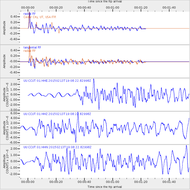
CCUT Cedar City, UT, USA - Earthquake Result Viewer
*The percent match for this event was below the threshold and hence no stack was calculated.
| Earthquake location: |
Northern Mid-Atlantic Ridge |
| Earthquake latitude/longitude: |
52.6/-31.9 |
| Earthquake time(UTC): |
2015/02/13 (044) 18:59:12 GMT |
| Earthquake Depth: |
16 km |
| Earthquake Magnitude: |
7.1 MWW, 6.8 MI, 7.0 MWB, 7.0 MWC, 7.1 MWC |
| Earthquake Catalog/Contributor: |
NEIC PDE/NEIC COMCAT |
|
| Network: |
UU University of Utah Regional Network |
| Station: |
CCUT Cedar City, UT, USA |
| Lat/Lon: |
37.55 N/113.36 W |
| Elevation: |
2127 m |
|
| Distance: |
56.4 deg |
| Az: |
289.381 deg |
| Baz: |
46.333 deg |
| Ray Param: |
$rayparam |
*The percent match for this event was below the threshold and hence was not used in the summary stack. |
|
| Radial Match: |
87.81167 % |
| Radial Bump: |
391 |
| Transverse Match: |
59.571026 % |
| Transverse Bump: |
400 |
| SOD ConfigId: |
7019011 |
| Insert Time: |
2019-04-16 19:31:35.948 +0000 |
| GWidth: |
2.5 |
| Max Bumps: |
400 |
| Tol: |
0.001 |
|
Signal To Noise
| Channel | StoN | STA | LTA |
| UU:CCUT:01:HHZ:20150213T19:08:22.82998Z | 1.6770891 | 4.286828E-7 | 2.556112E-7 |
| UU:CCUT:01:HHN:20150213T19:08:22.82998Z | 0.4280711 | 1.1420849E-7 | 2.6679794E-7 |
| UU:CCUT:01:HHE:20150213T19:08:22.82998Z | 0.74761647 | 1.7551778E-7 | 2.3476981E-7 |
| Arrivals |
| Ps | |
| PpPs | |
| PsPs/PpSs | |


