BIM Morne Bigot, Anses d'Arlets, Martinique - Earthquake Result Viewer
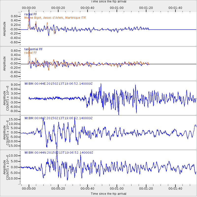
Earthquake location: Northern Mid-Atlantic Ridge
Earthquake latitude/longitude: 52.6/-31.9
Earthquake time(UTC): 2015/02/13 (044) 18:59:12 GMT
Earthquake Depth: 16 km
Earthquake Magnitude: 7.1 MWW, 6.8 MI, 7.0 MWB, 7.0 MWC, 7.1 MWC
Earthquake Catalog/Contributor: NEIC PDE/NEIC COMCAT
Network: WI West Indies IPGP Network
Station: BIM Morne Bigot, Anses d'Arlets, Martinique
Lat/Lon: 14.52 N/61.07 W
Elevation: 391 m
Distance: 44.5 deg
Az: 222.323 deg
Baz: 25.069 deg
Ray Param: 0.07184076
Estimated Moho Depth: 24.75 km
Estimated Crust Vp/Vs: 1.66
Assumed Crust Vp: 5.88 km/s
Estimated Crust Vs: 3.532 km/s
Estimated Crust Poisson's Ratio: 0.22
Radial Match: 90.60912 %
Radial Bump: 400
Transverse Match: 70.288666 %
Transverse Bump: 400
SOD ConfigId: 7019011
Insert Time: 2019-04-16 19:32:46.421 +0000
GWidth: 2.5
Max Bumps: 400
Tol: 0.001

Signal To Noise

ChannelStoNSTALTA
WI:BIM:00:HHZ:20150213T19:06:52.140009Z3.44335448.958321E-72.601626E-7
WI:BIM:00:HHN:20150213T19:06:52.140009Z1.54438666.193211E-74.0101426E-7
WI:BIM:00:HHE:20150213T19:06:52.140009Z1.18772674.6134323E-73.884254E-7
Arrivals
Ps3.0 SECOND
PpPs11 SECOND
PsPs/PpSs14 SECOND