You are here: Home > Network List > WI - West Indies IPGP Network Stations List
> Station GCMP Mount Pleasant, Carriacou, Grenada > Earthquake Result Viewer
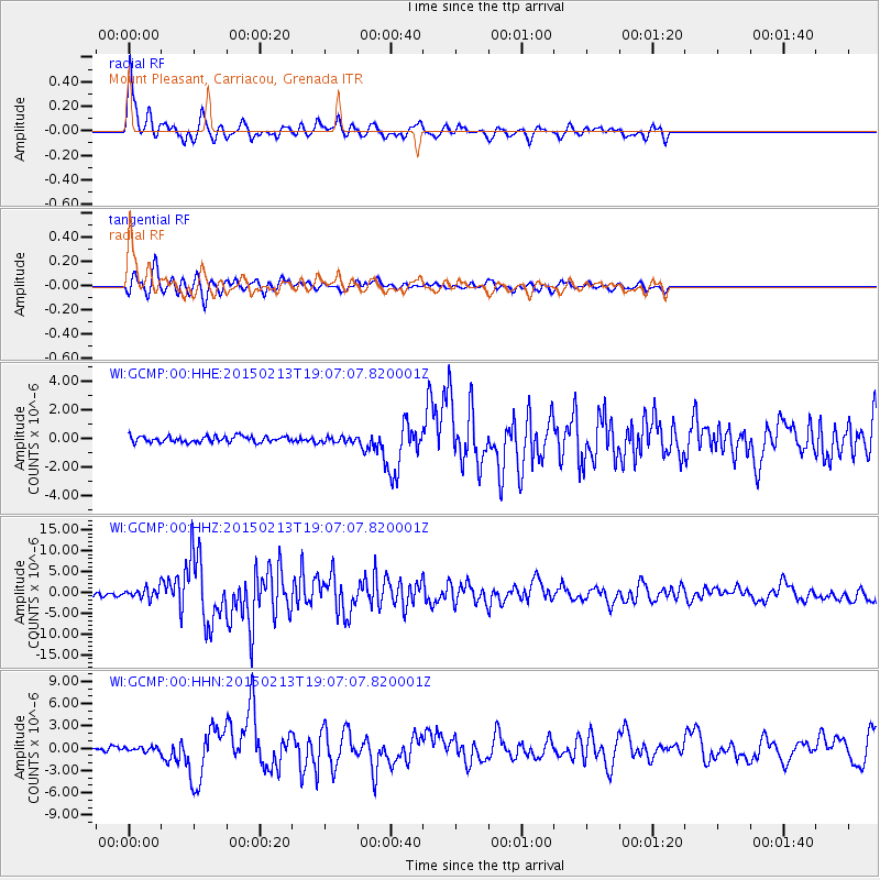
GCMP Mount Pleasant, Carriacou, Grenada - Earthquake Result Viewer

| Earthquake location: |
Northern Mid-Atlantic Ridge |
| Earthquake latitude/longitude: |
52.6/-31.9 |
| Earthquake time(UTC): |
2015/02/13 (044) 18:59:12 GMT |
| Earthquake Depth: |
16 km |
| Earthquake Magnitude: |
7.1 MWW, 6.8 MI, 7.0 MWB, 7.0 MWC, 7.1 MWC |
| Earthquake Catalog/Contributor: |
NEIC PDE/NEIC COMCAT |
|
| Network: |
WI West Indies IPGP Network |
| Station: |
GCMP Mount Pleasant, Carriacou, Grenada |
| Lat/Lon: |
12.49 N/61.43 W |
| Elevation: |
40 m |
|
| Distance: |
46.5 deg |
| Az: |
221.584 deg |
| Baz: |
24.468 deg |
| Ray Param: |
0.07058036 |
| Estimated Moho Depth: |
55.5 km |
| Estimated Crust Vp/Vs: |
2.10 |
| Assumed Crust Vp: |
5.738 km/s |
| Estimated Crust Vs: |
2.736 km/s |
| Estimated Crust Poisson's Ratio: |
0.35 |
|
| Radial Match: |
89.440575 % |
| Radial Bump: |
400 |
| Transverse Match: |
78.42609 % |
| Transverse Bump: |
400 |
| SOD ConfigId: |
7019011 |
| Insert Time: |
2019-04-16 19:32:46.740 +0000 |
| GWidth: |
2.5 |
| Max Bumps: |
400 |
| Tol: |
0.001 |
|
Signal To Noise
| Channel | StoN | STA | LTA |
| WI:GCMP:00:HHZ:20150213T19:07:07.820001Z | 3.41804 | 1.2062121E-6 | 3.5289585E-7 |
| WI:GCMP:00:HHN:20150213T19:07:07.820001Z | 0.9621889 | 2.9418467E-7 | 3.0574523E-7 |
| WI:GCMP:00:HHE:20150213T19:07:07.820001Z | 0.95439935 | 2.0441853E-7 | 2.1418553E-7 |
| Arrivals |
| Ps | 11 SECOND |
| PpPs | 29 SECOND |
| PsPs/PpSs | 40 SECOND |


