You are here: Home > Network List > CN - Canadian National Seismograph Network Stations List
> Station INK INUVIK, NT > Earthquake Result Viewer
INK INUVIK, NT - Earthquake Result Viewer
*The percent match for this event was below the threshold and hence no stack was calculated.
| Earthquake location: |
Solomon Islands |
| Earthquake latitude/longitude: |
-7.2/155.3 |
| Earthquake time(UTC): |
2014/04/20 (110) 00:15:58 GMT |
| Earthquake Depth: |
18 km |
| Earthquake Magnitude: |
6.1 MWP |
| Earthquake Catalog/Contributor: |
NEIC PDE/NEIC COMCAT |
|
| Network: |
CN Canadian National Seismograph Network |
| Station: |
INK INUVIK, NT |
| Lat/Lon: |
68.31 N/133.53 W |
| Elevation: |
44 m |
|
| Distance: |
89.8 deg |
| Az: |
20.602 deg |
| Baz: |
249.909 deg |
| Ray Param: |
$rayparam |
*The percent match for this event was below the threshold and hence was not used in the summary stack. |
|
| Radial Match: |
61.12369 % |
| Radial Bump: |
374 |
| Transverse Match: |
62.165962 % |
| Transverse Bump: |
400 |
| SOD ConfigId: |
626651 |
| Insert Time: |
2014-05-04 00:33:38.490 +0000 |
| GWidth: |
2.5 |
| Max Bumps: |
400 |
| Tol: |
0.001 |
|
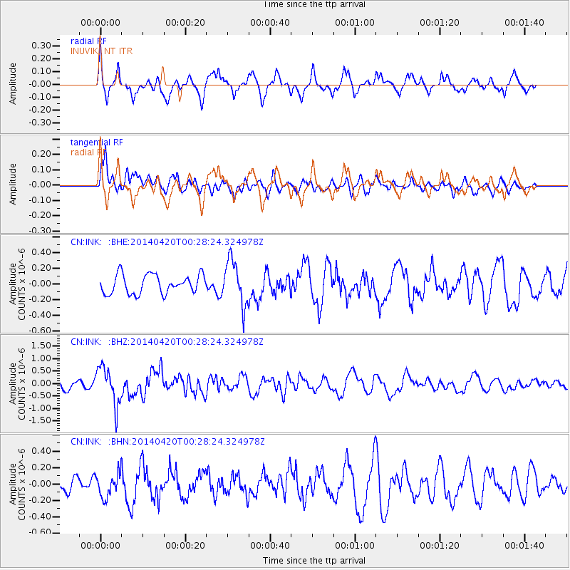
Signal To Noise
| Channel | StoN | STA | LTA |
| CN:INK: :BHZ:20140420T00:28:24.324978Z | 3.983951 | 7.681456E-7 | 1.9280999E-7 |
| CN:INK: :BHN:20140420T00:28:24.324978Z | 1.0182137 | 1.437096E-7 | 1.4113893E-7 |
| CN:INK: :BHE:20140420T00:28:24.324978Z | 2.4231339 | 2.9281628E-7 | 1.2084197E-7 |
| Arrivals |
| Ps | |
| PpPs | |
| PsPs/PpSs | |


