You are here: Home > Network List > TA - USArray Transportable Network (new EarthScope stations) Stations List
> Station A36M Sachs Harbour, NT, CAN > Earthquake Result Viewer
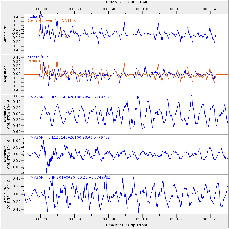
A36M Sachs Harbour, NT, CAN - Earthquake Result Viewer
*The percent match for this event was below the threshold and hence no stack was calculated.
| Earthquake location: |
Solomon Islands |
| Earthquake latitude/longitude: |
-7.2/155.3 |
| Earthquake time(UTC): |
2014/04/20 (110) 00:15:58 GMT |
| Earthquake Depth: |
18 km |
| Earthquake Magnitude: |
6.1 MWP |
| Earthquake Catalog/Contributor: |
NEIC PDE/NEIC COMCAT |
|
| Network: |
TA USArray Transportable Network (new EarthScope stations) |
| Station: |
A36M Sachs Harbour, NT, CAN |
| Lat/Lon: |
71.99 N/125.25 W |
| Elevation: |
32 m |
|
| Distance: |
93.5 deg |
| Az: |
17.844 deg |
| Baz: |
257.774 deg |
| Ray Param: |
$rayparam |
*The percent match for this event was below the threshold and hence was not used in the summary stack. |
|
| Radial Match: |
75.37566 % |
| Radial Bump: |
400 |
| Transverse Match: |
82.384445 % |
| Transverse Bump: |
400 |
| SOD ConfigId: |
626651 |
| Insert Time: |
2014-05-04 00:41:18.898 +0000 |
| GWidth: |
2.5 |
| Max Bumps: |
400 |
| Tol: |
0.001 |
|
Signal To Noise
| Channel | StoN | STA | LTA |
| TA:A36M: :BHZ:20140420T00:28:41.574978Z | 6.065626 | 6.601406E-7 | 1.0883304E-7 |
| TA:A36M: :BHN:20140420T00:28:41.574978Z | 0.95006424 | 1.3594402E-7 | 1.430893E-7 |
| TA:A36M: :BHE:20140420T00:28:41.574978Z | 0.90125847 | 1.708575E-7 | 1.895766E-7 |
| Arrivals |
| Ps | |
| PpPs | |
| PsPs/PpSs | |


