You are here: Home > Network List > WY - Yellowstone Wyoming Seismic Network Stations List
> Station YUF Upper Falls, WY, USA > Earthquake Result Viewer
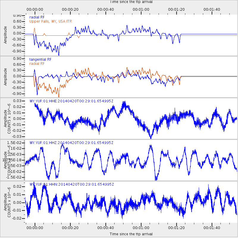
YUF Upper Falls, WY, USA - Earthquake Result Viewer
*The percent match for this event was below the threshold and hence no stack was calculated.
| Earthquake location: |
Solomon Islands |
| Earthquake latitude/longitude: |
-7.2/155.3 |
| Earthquake time(UTC): |
2014/04/20 (110) 00:15:58 GMT |
| Earthquake Depth: |
18 km |
| Earthquake Magnitude: |
6.1 MWP |
| Earthquake Catalog/Contributor: |
NEIC PDE/NEIC COMCAT |
|
| Network: |
WY Yellowstone Wyoming Seismic Network |
| Station: |
YUF Upper Falls, WY, USA |
| Lat/Lon: |
44.71 N/110.51 W |
| Elevation: |
2394 m |
|
| Distance: |
98.0 deg |
| Az: |
45.891 deg |
| Baz: |
267.818 deg |
| Ray Param: |
$rayparam |
*The percent match for this event was below the threshold and hence was not used in the summary stack. |
|
| Radial Match: |
57.619602 % |
| Radial Bump: |
400 |
| Transverse Match: |
59.377346 % |
| Transverse Bump: |
400 |
| SOD ConfigId: |
626651 |
| Insert Time: |
2014-05-04 00:45:15.649 +0000 |
| GWidth: |
2.5 |
| Max Bumps: |
400 |
| Tol: |
0.001 |
|
Signal To Noise
| Channel | StoN | STA | LTA |
| WY:YUF:01:HHZ:20140420T00:29:01.654995Z | 2.588632 | 6.424799E-9 | 2.4819282E-9 |
| WY:YUF:01:HHN:20140420T00:29:01.654995Z | 1.6330942 | 1.1602049E-8 | 7.104336E-9 |
| WY:YUF:01:HHE:20140420T00:29:01.654995Z | 1.2595545 | 1.2477478E-8 | 9.9062625E-9 |
| Arrivals |
| Ps | |
| PpPs | |
| PsPs/PpSs | |


