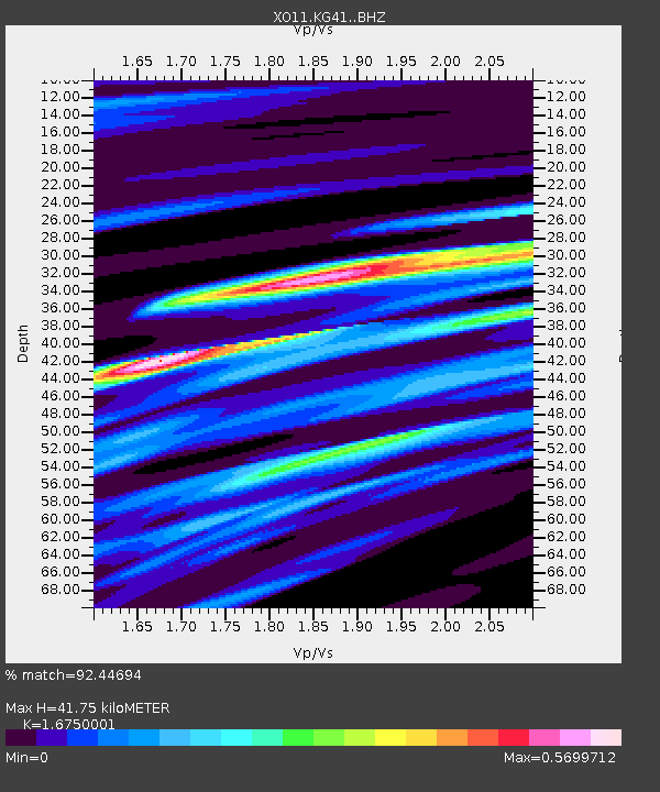
KG41 KG41 of OIINK Flexarray - Earthquake Result Viewer

Earthquake location: Northern Mid-Atlantic Ridge
Earthquake latitude/longitude: 52.6/-31.9
Earthquake time(UTC): 2015/02/13 (044) 18:59:12 GMT
Earthquake Depth: 16 km
Earthquake Magnitude: 7.1 MWW, 6.8 MI, 7.0 MWB, 7.0 MWC, 7.1 MWC
Earthquake Catalog/Contributor: NEIC PDE/NEIC COMCAT
Network: XO Ozark Illinois, Indiana and Kentucky ES Flexible Array
Station: KG41 KG41 of OIINK Flexarray
Lat/Lon: 37.67 N/85.74 W
Elevation: 274 m
Distance: 39.9 deg
Az: 269.981 deg
Baz: 50.175 deg
Ray Param: 0.074722074
Estimated Moho Depth: 41.75 km
Estimated Crust Vp/Vs: 1.68
Assumed Crust Vp: 6.476 km/s
Estimated Crust Vs: 3.866 km/s
Estimated Crust Poisson's Ratio: 0.22
Radial Match: 92.44694 %
Radial Bump: 335
Transverse Match: 48.145817 %
Transverse Bump: 400
SOD ConfigId: 7019011
Insert Time: 2019-04-16 19:34:09.902 +0000
GWidth: 2.5
Max Bumps: 400
Tol: 0.001

Signal To Noise

ChannelStoNSTALTA
XO:KG41: :BHZ:20150213T19:06:14.580011Z2.0261567.904683E-73.90132E-7
XO:KG41: :BHN:20150213T19:06:14.580011Z1.30790369.3235354E-77.12861E-7
XO:KG41: :BHE:20150213T19:06:14.580011Z2.41422651.836241E-67.6059183E-7
Arrivals
Ps4.7 SECOND
PpPs16 SECOND
PsPs/PpSs21 SECOND