You are here: Home > Network List > TA - USArray Transportable Network (new EarthScope stations) Stations List
> Station O03E Paynes Creek, CA, USA > Earthquake Result Viewer
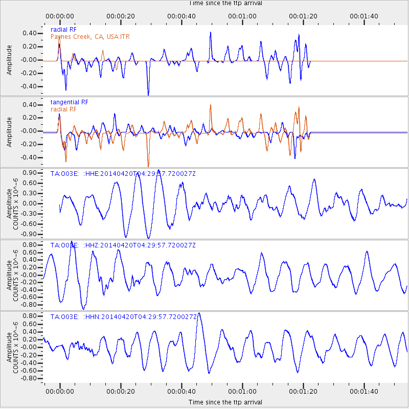
O03E Paynes Creek, CA, USA - Earthquake Result Viewer
*The percent match for this event was below the threshold and hence no stack was calculated.
| Earthquake location: |
Solomon Islands |
| Earthquake latitude/longitude: |
-6.9/154.6 |
| Earthquake time(UTC): |
2014/04/20 (110) 04:17:34 GMT |
| Earthquake Depth: |
28 km |
| Earthquake Magnitude: |
5.7 MWP |
| Earthquake Catalog/Contributor: |
NEIC PDE/NEIC COMCAT |
|
| Network: |
TA USArray Transportable Network (new EarthScope stations) |
| Station: |
O03E Paynes Creek, CA, USA |
| Lat/Lon: |
40.29 N/121.80 W |
| Elevation: |
967 m |
|
| Distance: |
89.6 deg |
| Az: |
49.479 deg |
| Baz: |
260.695 deg |
| Ray Param: |
$rayparam |
*The percent match for this event was below the threshold and hence was not used in the summary stack. |
|
| Radial Match: |
79.40886 % |
| Radial Bump: |
400 |
| Transverse Match: |
51.769604 % |
| Transverse Bump: |
400 |
| SOD ConfigId: |
626651 |
| Insert Time: |
2014-05-04 04:32:34.358 +0000 |
| GWidth: |
2.5 |
| Max Bumps: |
400 |
| Tol: |
0.001 |
|
Signal To Noise
| Channel | StoN | STA | LTA |
| TA:O03E: :HHZ:20140420T04:29:57.720027Z | 2.4403963 | 5.6636253E-7 | 2.320781E-7 |
| TA:O03E: :HHN:20140420T04:29:57.720027Z | 0.59055257 | 1.2341465E-7 | 2.0898165E-7 |
| TA:O03E: :HHE:20140420T04:29:57.720027Z | 1.8725824 | 7.1032855E-7 | 3.7933097E-7 |
| Arrivals |
| Ps | |
| PpPs | |
| PsPs/PpSs | |


