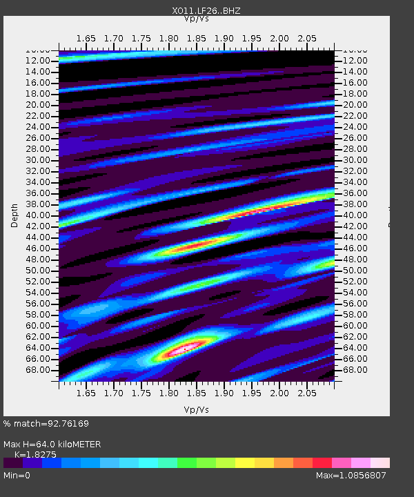
LF26 LF26 of OIINK Flexarray - Earthquake Result Viewer

Earthquake location: Northern Mid-Atlantic Ridge
Earthquake latitude/longitude: 52.6/-31.9
Earthquake time(UTC): 2015/02/13 (044) 18:59:12 GMT
Earthquake Depth: 16 km
Earthquake Magnitude: 7.1 MWW, 6.8 MI, 7.0 MWB, 7.0 MWC, 7.1 MWC
Earthquake Catalog/Contributor: NEIC PDE/NEIC COMCAT
Network: XO Ozark Illinois, Indiana and Kentucky ES Flexible Array
Station: LF26 LF26 of OIINK Flexarray
Lat/Lon: 37.74 N/88.13 W
Elevation: 158 m
Distance: 41.3 deg
Az: 271.939 deg
Baz: 50.208 deg
Ray Param: 0.07388673
Estimated Moho Depth: 64.0 km
Estimated Crust Vp/Vs: 1.83
Assumed Crust Vp: 6.444 km/s
Estimated Crust Vs: 3.526 km/s
Estimated Crust Poisson's Ratio: 0.29
Radial Match: 92.76169 %
Radial Bump: 400
Transverse Match: 66.807434 %
Transverse Bump: 400
SOD ConfigId: 7019011
Insert Time: 2019-04-16 19:34:26.070 +0000
GWidth: 2.5
Max Bumps: 400
Tol: 0.001

Signal To Noise

ChannelStoNSTALTA
XO:LF26: :BHZ:20150213T19:06:26.195001Z1.45704648.4767447E-75.817759E-7
XO:LF26: :BHN:20150213T19:06:26.195001Z0.82001386.611709E-78.062924E-7
XO:LF26: :BHE:20150213T19:06:26.195001Z0.70678214.161194E-75.887521E-7
Arrivals
Ps8.8 SECOND
PpPs26 SECOND
PsPs/PpSs35 SECOND