KAPI Kappang, Sulawesi, Indonesia - Earthquake Result Viewer
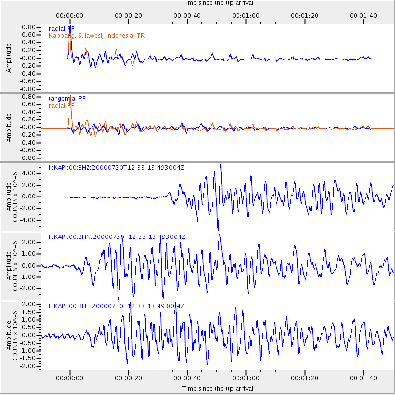
Earthquake location: Southeast Of Honshu, Japan
Earthquake latitude/longitude: 33.9/139.4
Earthquake time(UTC): 2000/07/30 (212) 12:25:45 GMT
Earthquake Depth: 10 km
Earthquake Magnitude: 6.0 MB, 6.5 MS, 6.5 MW, 6.5 MW
Earthquake Catalog/Contributor: WHDF/NEIC
Network: II Global Seismograph Network (GSN - IRIS/IDA)
Station: KAPI Kappang, Sulawesi, Indonesia
Lat/Lon: 5.01 S/119.75 E
Elevation: 300 m
Distance: 42.9 deg
Az: 209.426 deg
Baz: 24.216 deg
Ray Param: 0.072880164
Estimated Moho Depth: 14.0 km
Estimated Crust Vp/Vs: 2.08
Assumed Crust Vp: 6.343 km/s
Estimated Crust Vs: 3.05 km/s
Estimated Crust Poisson's Ratio: 0.35
Radial Match: 92.54161 %
Radial Bump: 400
Transverse Match: 92.95613 %
Transverse Bump: 376
SOD ConfigId: 3744
Insert Time: 2010-03-01 21:25:21.842 +0000
GWidth: 2.5
Max Bumps: 400
Tol: 0.001

Signal To Noise

ChannelStoNSTALTA
II:KAPI:00:BHN:20000730T12:33:13.493004Z3.1790022.566885E-78.0745004E-8
II:KAPI:00:BHE:20000730T12:33:13.493004Z1.60043691.230341E-77.6875324E-8
II:KAPI:00:BHZ:20000730T12:33:13.493004Z4.6132233.6425337E-77.895854E-8
Arrivals
Ps2.5 SECOND
PpPs6.4 SECOND
PsPs/PpSs9.0 SECOND