You are here: Home > Network List > TA - USArray Transportable Network (new EarthScope stations) Stations List
> Station O03E Paynes Creek, CA, USA > Earthquake Result Viewer
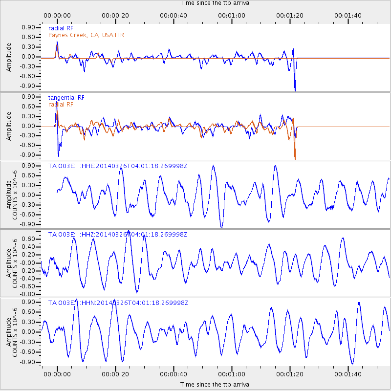
O03E Paynes Creek, CA, USA - Earthquake Result Viewer
*The percent match for this event was below the threshold and hence no stack was calculated.
| Earthquake location: |
Kermadec Islands Region |
| Earthquake latitude/longitude: |
-27.6/-170.6 |
| Earthquake time(UTC): |
2014/03/26 (085) 03:49:33 GMT |
| Earthquake Depth: |
15 km |
| Earthquake Magnitude: |
6.0 MB |
| Earthquake Catalog/Contributor: |
NEIC PDE/NEIC COMCAT |
|
| Network: |
TA USArray Transportable Network (new EarthScope stations) |
| Station: |
O03E Paynes Creek, CA, USA |
| Lat/Lon: |
40.29 N/121.80 W |
| Elevation: |
967 m |
|
| Distance: |
81.4 deg |
| Az: |
35.593 deg |
| Baz: |
222.459 deg |
| Ray Param: |
$rayparam |
*The percent match for this event was below the threshold and hence was not used in the summary stack. |
|
| Radial Match: |
46.96905 % |
| Radial Bump: |
400 |
| Transverse Match: |
62.56005 % |
| Transverse Bump: |
400 |
| SOD ConfigId: |
626651 |
| Insert Time: |
2014-05-05 00:19:24.295 +0000 |
| GWidth: |
2.5 |
| Max Bumps: |
400 |
| Tol: |
0.001 |
|
Signal To Noise
| Channel | StoN | STA | LTA |
| TA:O03E: :HHZ:20140326T04:01:18.269998Z | 0.8629136 | 1.850691E-7 | 2.1447002E-7 |
| TA:O03E: :HHN:20140326T04:01:18.269998Z | 1.052326 | 3.3017417E-7 | 3.1375657E-7 |
| TA:O03E: :HHE:20140326T04:01:18.269998Z | 1.3191583 | 4.4053624E-7 | 3.3395253E-7 |
| Arrivals |
| Ps | |
| PpPs | |
| PsPs/PpSs | |


