You are here: Home > Network List > UW - Pacific Northwest Regional Seismic Network Stations List
> Station PASS Maple Falls, WA, USA > Earthquake Result Viewer
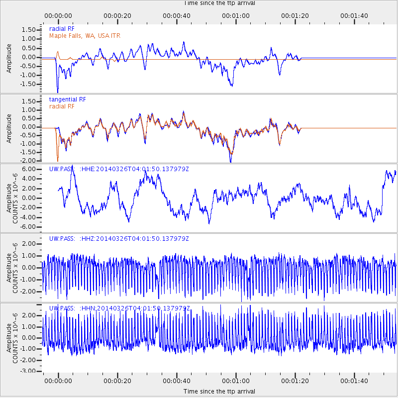
PASS Maple Falls, WA, USA - Earthquake Result Viewer
*The percent match for this event was below the threshold and hence no stack was calculated.
| Earthquake location: |
Kermadec Islands Region |
| Earthquake latitude/longitude: |
-27.6/-170.6 |
| Earthquake time(UTC): |
2014/03/26 (085) 03:49:33 GMT |
| Earthquake Depth: |
15 km |
| Earthquake Magnitude: |
6.0 MB |
| Earthquake Catalog/Contributor: |
NEIC PDE/NEIC COMCAT |
|
| Network: |
UW Pacific Northwest Regional Seismic Network |
| Station: |
PASS Maple Falls, WA, USA |
| Lat/Lon: |
49.00 N/122.09 W |
| Elevation: |
174 m |
|
| Distance: |
87.7 deg |
| Az: |
29.587 deg |
| Baz: |
221.689 deg |
| Ray Param: |
$rayparam |
*The percent match for this event was below the threshold and hence was not used in the summary stack. |
|
| Radial Match: |
36.99508 % |
| Radial Bump: |
354 |
| Transverse Match: |
35.432507 % |
| Transverse Bump: |
359 |
| SOD ConfigId: |
626651 |
| Insert Time: |
2014-05-05 00:21:05.256 +0000 |
| GWidth: |
2.5 |
| Max Bumps: |
400 |
| Tol: |
0.001 |
|
Signal To Noise
| Channel | StoN | STA | LTA |
| UW:PASS: :HHZ:20140326T04:01:50.137979Z | 1.1751351 | 9.97999E-7 | 8.492632E-7 |
| UW:PASS: :HHN:20140326T04:01:50.137979Z | 1.1673919 | 1.0937075E-6 | 9.368812E-7 |
| UW:PASS: :HHE:20140326T04:01:50.137979Z | 1.7428645 | 4.395913E-6 | 2.5222346E-6 |
| Arrivals |
| Ps | |
| PpPs | |
| PsPs/PpSs | |


