You are here: Home > Network List > TA - USArray Transportable Network (new EarthScope stations) Stations List
> Station L44A Lake County Forest Preserve, Grayslake, IL, USA > Earthquake Result Viewer
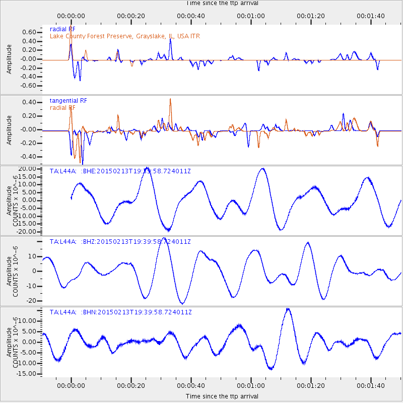
L44A Lake County Forest Preserve, Grayslake, IL, USA - Earthquake Result Viewer
*The percent match for this event was below the threshold and hence no stack was calculated.
| Earthquake location: |
Reykjanes Ridge |
| Earthquake latitude/longitude: |
52.7/-32.3 |
| Earthquake time(UTC): |
2015/02/13 (044) 19:33:11 GMT |
| Earthquake Depth: |
18 km |
| Earthquake Magnitude: |
5.2 mb |
| Earthquake Catalog/Contributor: |
ISC/ISC |
|
| Network: |
TA USArray Transportable Network (new EarthScope stations) |
| Station: |
L44A Lake County Forest Preserve, Grayslake, IL, USA |
| Lat/Lon: |
42.18 N/87.91 W |
| Elevation: |
202 m |
|
| Distance: |
38.1 deg |
| Az: |
276.891 deg |
| Baz: |
54.441 deg |
| Ray Param: |
$rayparam |
*The percent match for this event was below the threshold and hence was not used in the summary stack. |
|
| Radial Match: |
77.38925 % |
| Radial Bump: |
380 |
| Transverse Match: |
55.28947 % |
| Transverse Bump: |
365 |
| SOD ConfigId: |
7019011 |
| Insert Time: |
2019-04-16 19:41:42.642 +0000 |
| GWidth: |
2.5 |
| Max Bumps: |
400 |
| Tol: |
0.001 |
|
Signal To Noise
| Channel | StoN | STA | LTA |
| TA:L44A: :BHZ:20150213T19:39:58.724011Z | 0.88188463 | 5.3539807E-6 | 6.071067E-6 |
| TA:L44A: :BHN:20150213T19:39:58.724011Z | 1.0198392 | 4.0074488E-6 | 3.9294905E-6 |
| TA:L44A: :BHE:20150213T19:39:58.724011Z | 1.7875787 | 1.5195281E-5 | 8.500482E-6 |
| Arrivals |
| Ps | |
| PpPs | |
| PsPs/PpSs | |


