You are here: Home > Network List > II - Global Seismograph Network (GSN - IRIS/IDA) Stations List
> Station KAPI Kappang, Sulawesi, Indonesia > Earthquake Result Viewer
KAPI Kappang, Sulawesi, Indonesia - Earthquake Result Viewer
| Earthquake location: |
Vanuatu Islands Region |
| Earthquake latitude/longitude: |
-19.5/173.8 |
| Earthquake time(UTC): |
2000/02/25 (056) 01:43:58 GMT |
| Earthquake Depth: |
33 km |
| Earthquake Magnitude: |
6.1 MB, 7.1 MS, 7.1 MW, 7.0 MW |
| Earthquake Catalog/Contributor: |
WHDF/NEIC |
|
| Network: |
II Global Seismograph Network (GSN - IRIS/IDA) |
| Station: |
KAPI Kappang, Sulawesi, Indonesia |
| Lat/Lon: |
5.01 S/119.75 E |
| Elevation: |
300 m |
|
| Distance: |
54.5 deg |
| Az: |
277.931 deg |
| Baz: |
110.331 deg |
| Ray Param: |
0.06533231 |
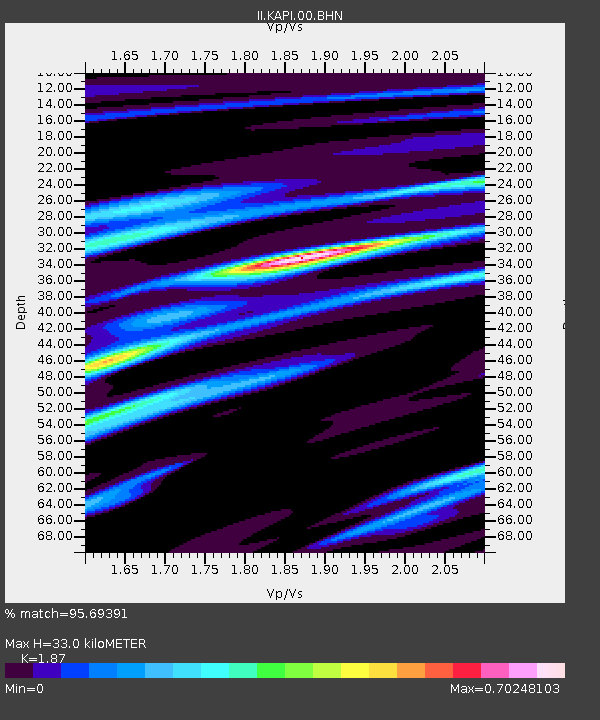
| Estimated Moho Depth: |
33.0 km |
| Estimated Crust Vp/Vs: |
1.87 |
| Assumed Crust Vp: |
6.343 km/s |
| Estimated Crust Vs: |
3.392 km/s |
| Estimated Crust Poisson's Ratio: |
0.30 |
|
| Radial Match: |
95.69391 % |
| Radial Bump: |
233 |
| Transverse Match: |
82.10517 % |
| Transverse Bump: |
350 |
| SOD ConfigId: |
3744 |
| Insert Time: |
2010-03-01 21:26:06.737 +0000 |
| GWidth: |
2.5 |
| Max Bumps: |
400 |
| Tol: |
0.001 |
|
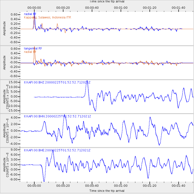
Signal To Noise
| Channel | StoN | STA | LTA |
| II:KAPI:00:BHN:20000225T01:52:52.712021Z | 0.5288136 | 5.2500454E-8 | 9.9279696E-8 |
| II:KAPI:00:BHE:20000225T01:52:52.712021Z | 0.7631657 | 8.972703E-8 | 1.1757214E-7 |
| II:KAPI:00:BHZ:20000225T01:52:52.712021Z | 2.40722 | 2.939131E-7 | 1.220965E-7 |
| Arrivals |
| Ps | 4.8 SECOND |
| PpPs | 14 SECOND |
| PsPs/PpSs | 19 SECOND |


