You are here: Home > Network List > US - United States National Seismic Network Stations List
> Station EGMT Eagleton, Montana, USA > Earthquake Result Viewer
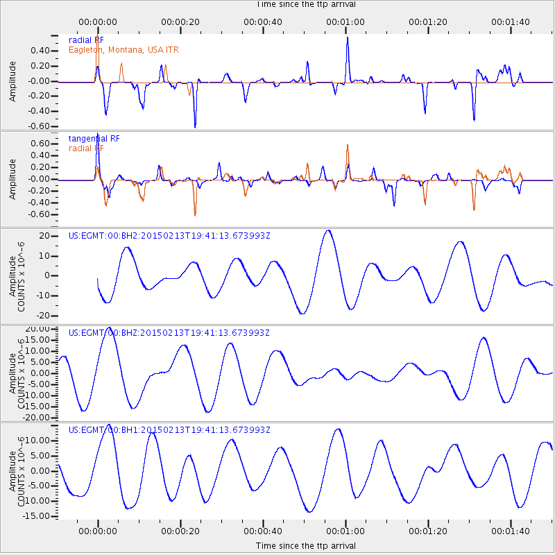
EGMT Eagleton, Montana, USA - Earthquake Result Viewer
*The percent match for this event was below the threshold and hence no stack was calculated.
| Earthquake location: |
Reykjanes Ridge |
| Earthquake latitude/longitude: |
52.7/-32.3 |
| Earthquake time(UTC): |
2015/02/13 (044) 19:33:11 GMT |
| Earthquake Depth: |
18 km |
| Earthquake Magnitude: |
5.2 mb |
| Earthquake Catalog/Contributor: |
ISC/ISC |
|
| Network: |
US United States National Seismic Network |
| Station: |
EGMT Eagleton, Montana, USA |
| Lat/Lon: |
48.02 N/109.75 W |
| Elevation: |
1055 m |
|
| Distance: |
47.4 deg |
| Az: |
297.107 deg |
| Baz: |
53.868 deg |
| Ray Param: |
$rayparam |
*The percent match for this event was below the threshold and hence was not used in the summary stack. |
|
| Radial Match: |
74.478096 % |
| Radial Bump: |
216 |
| Transverse Match: |
57.4544 % |
| Transverse Bump: |
400 |
| SOD ConfigId: |
7019011 |
| Insert Time: |
2019-04-16 19:42:28.461 +0000 |
| GWidth: |
2.5 |
| Max Bumps: |
400 |
| Tol: |
0.001 |
|
Signal To Noise
| Channel | StoN | STA | LTA |
| US:EGMT:00:BHZ:20150213T19:41:13.673993Z | 2.3591955 | 1.4907685E-5 | 6.31897E-6 |
| US:EGMT:00:BH1:20150213T19:41:13.673993Z | 2.0034645 | 1.1564636E-5 | 5.772319E-6 |
| US:EGMT:00:BH2:20150213T19:41:13.673993Z | 0.9208836 | 6.7184014E-6 | 7.295603E-6 |
| Arrivals |
| Ps | |
| PpPs | |
| PsPs/PpSs | |


