You are here: Home > Network List > UW - Pacific Northwest Regional Seismic Network Stations List
> Station MRBL Marblemount, WA, USA > Earthquake Result Viewer
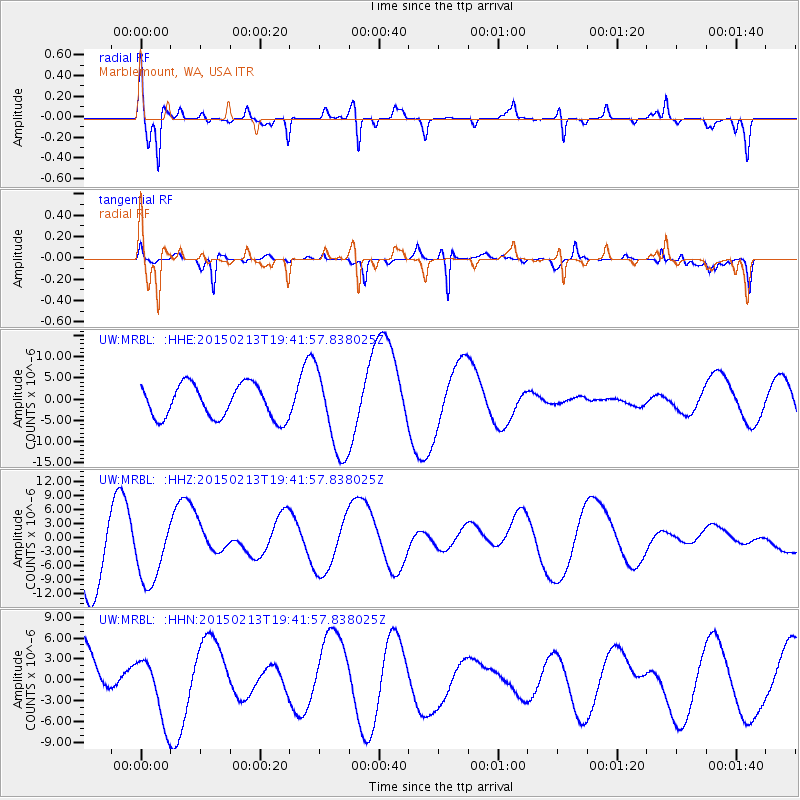
MRBL Marblemount, WA, USA - Earthquake Result Viewer
*The percent match for this event was below the threshold and hence no stack was calculated.
| Earthquake location: |
Reykjanes Ridge |
| Earthquake latitude/longitude: |
52.7/-32.3 |
| Earthquake time(UTC): |
2015/02/13 (044) 19:33:11 GMT |
| Earthquake Depth: |
18 km |
| Earthquake Magnitude: |
5.2 mb |
| Earthquake Catalog/Contributor: |
ISC/ISC |
|
| Network: |
UW Pacific Northwest Regional Seismic Network |
| Station: |
MRBL Marblemount, WA, USA |
| Lat/Lon: |
48.52 N/121.48 W |
| Elevation: |
75 m |
|
| Distance: |
53.2 deg |
| Az: |
303.917 deg |
| Baz: |
49.484 deg |
| Ray Param: |
$rayparam |
*The percent match for this event was below the threshold and hence was not used in the summary stack. |
|
| Radial Match: |
76.48519 % |
| Radial Bump: |
335 |
| Transverse Match: |
75.33942 % |
| Transverse Bump: |
329 |
| SOD ConfigId: |
7019011 |
| Insert Time: |
2019-04-16 19:42:39.417 +0000 |
| GWidth: |
2.5 |
| Max Bumps: |
400 |
| Tol: |
0.001 |
|
Signal To Noise
| Channel | StoN | STA | LTA |
| UW:MRBL: :HHZ:20150213T19:41:57.838025Z | 0.53588694 | 7.488076E-6 | 1.3973237E-5 |
| UW:MRBL: :HHN:20150213T19:41:57.838025Z | 1.0581117 | 4.6085E-6 | 4.3554005E-6 |
| UW:MRBL: :HHE:20150213T19:41:57.838025Z | 2.542779 | 9.994615E-6 | 3.930587E-6 |
| Arrivals |
| Ps | |
| PpPs | |
| PsPs/PpSs | |


