You are here: Home > Network List > II - Global Seismograph Network (GSN - IRIS/IDA) Stations List
> Station KAPI Kappang, Sulawesi, Indonesia > Earthquake Result Viewer
KAPI Kappang, Sulawesi, Indonesia - Earthquake Result Viewer
| Earthquake location: |
Santa Cruz Islands |
| Earthquake latitude/longitude: |
-11.4/165.4 |
| Earthquake time(UTC): |
2000/01/05 (005) 07:40:40 GMT |
| Earthquake Depth: |
33 km |
| Earthquake Magnitude: |
5.7 MB, 6.0 MS, 6.2 MW, 6.1 MW |
| Earthquake Catalog/Contributor: |
WHDF/NEIC |
|
| Network: |
II Global Seismograph Network (GSN - IRIS/IDA) |
| Station: |
KAPI Kappang, Sulawesi, Indonesia |
| Lat/Lon: |
5.01 S/119.75 E |
| Elevation: |
300 m |
|
| Distance: |
45.6 deg |
| Az: |
274.123 deg |
| Baz: |
100.95 deg |
| Ray Param: |
0.071132176 |
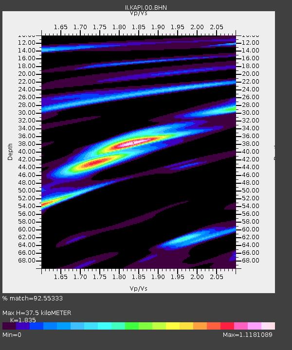
| Estimated Moho Depth: |
37.5 km |
| Estimated Crust Vp/Vs: |
1.84 |
| Assumed Crust Vp: |
6.343 km/s |
| Estimated Crust Vs: |
3.457 km/s |
| Estimated Crust Poisson's Ratio: |
0.29 |
|
| Radial Match: |
92.55333 % |
| Radial Bump: |
286 |
| Transverse Match: |
86.58666 % |
| Transverse Bump: |
400 |
| SOD ConfigId: |
3744 |
| Insert Time: |
2010-03-01 21:26:32.321 +0000 |
| GWidth: |
2.5 |
| Max Bumps: |
400 |
| Tol: |
0.001 |
|
Signal To Noise
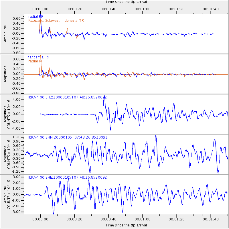
| Channel | StoN | STA | LTA |
| II:KAPI:00:BHN:20000105T07:48:26.852009Z | 1.2391117 | 9.0134776E-8 | 7.274145E-8 |
| II:KAPI:00:BHE:20000105T07:48:26.852009Z | 6.885321 | 5.779594E-7 | 8.3940805E-8 |
| II:KAPI:00:BHZ:20000105T07:48:26.852009Z | 8.537294 | 8.320438E-7 | 9.745989E-8 |
| Arrivals |
| Ps | 5.2 SECOND |
| PpPs | 16 SECOND |
| PsPs/PpSs | 21 SECOND |


