You are here: Home > Network List > II - Global Seismograph Network (GSN - IRIS/IDA) Stations List
> Station KAPI Kappang, Sulawesi, Indonesia > Earthquake Result Viewer
KAPI Kappang, Sulawesi, Indonesia - Earthquake Result Viewer
| Earthquake location: |
South Of Australia |
| Earthquake latitude/longitude: |
-50.6/139.6 |
| Earthquake time(UTC): |
2000/06/11 (163) 11:55:12 GMT |
| Earthquake Depth: |
10 km |
| Earthquake Magnitude: |
5.9 MB, 6.4 MS, 6.6 MW, 6.4 MW |
| Earthquake Catalog/Contributor: |
WHDF/NEIC |
|
| Network: |
II Global Seismograph Network (GSN - IRIS/IDA) |
| Station: |
KAPI Kappang, Sulawesi, Indonesia |
| Lat/Lon: |
5.01 S/119.75 E |
| Elevation: |
300 m |
|
| Distance: |
48.4 deg |
| Az: |
333.158 deg |
| Baz: |
163.204 deg |
| Ray Param: |
0.06941439 |
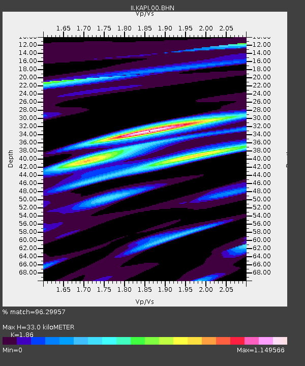
| Estimated Moho Depth: |
33.0 km |
| Estimated Crust Vp/Vs: |
1.86 |
| Assumed Crust Vp: |
6.343 km/s |
| Estimated Crust Vs: |
3.41 km/s |
| Estimated Crust Poisson's Ratio: |
0.30 |
|
| Radial Match: |
96.29957 % |
| Radial Bump: |
400 |
| Transverse Match: |
91.486534 % |
| Transverse Bump: |
400 |
| SOD ConfigId: |
3744 |
| Insert Time: |
2010-03-01 21:26:38.368 +0000 |
| GWidth: |
2.5 |
| Max Bumps: |
400 |
| Tol: |
0.001 |
|

Signal To Noise
| Channel | StoN | STA | LTA |
| II:KAPI:00:BHN:20000611T12:03:23.161014Z | 2.4590962 | 1.7588418E-7 | 7.1523914E-8 |
| II:KAPI:00:BHE:20000611T12:03:23.161014Z | 1.9854863 | 1.1159134E-7 | 5.620353E-8 |
| II:KAPI:00:BHZ:20000611T12:03:23.161014Z | 5.2950974 | 4.2691593E-7 | 8.062476E-8 |
| Arrivals |
| Ps | 4.7 SECOND |
| PpPs | 14 SECOND |
| PsPs/PpSs | 19 SECOND |


