You are here: Home > Network List > IU - Global Seismograph Network (GSN - IRIS/USGS) Stations List
> Station POHA Pohakuloa, Hawaii, USA > Earthquake Result Viewer
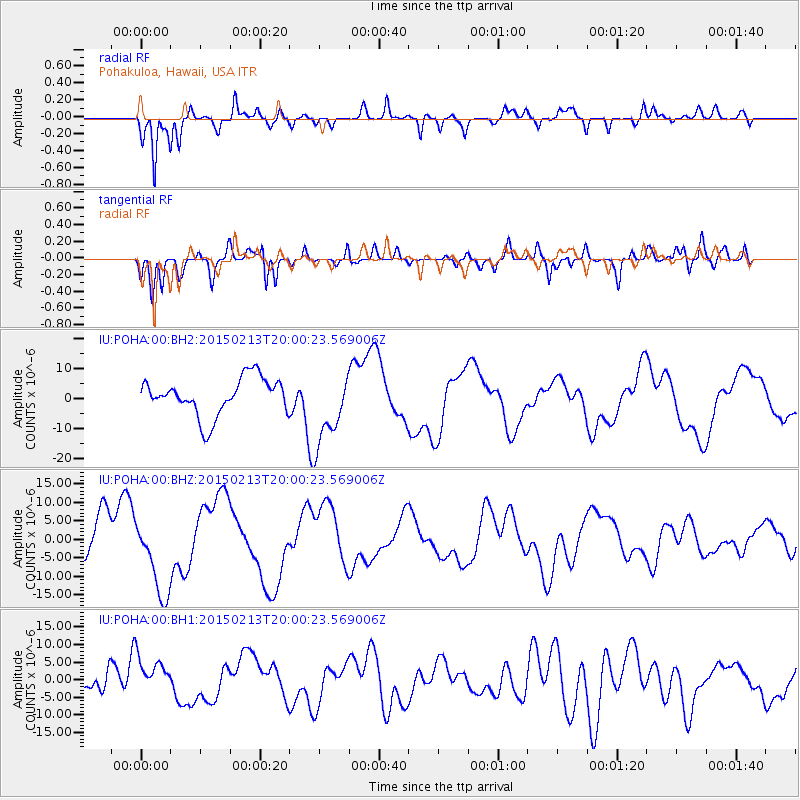
POHA Pohakuloa, Hawaii, USA - Earthquake Result Viewer
*The percent match for this event was below the threshold and hence no stack was calculated.
| Earthquake location: |
Northern Mid-Atlantic Ridge |
| Earthquake latitude/longitude: |
52.7/-31.9 |
| Earthquake time(UTC): |
2015/02/13 (044) 19:47:42 GMT |
| Earthquake Depth: |
13 km |
| Earthquake Magnitude: |
4.8 mb |
| Earthquake Catalog/Contributor: |
ISC/ISC |
|
| Network: |
IU Global Seismograph Network (GSN - IRIS/USGS) |
| Station: |
POHA Pohakuloa, Hawaii, USA |
| Lat/Lon: |
19.76 N/155.53 W |
| Elevation: |
1990 m |
|
| Distance: |
92.9 deg |
| Az: |
308.248 deg |
| Baz: |
30.481 deg |
| Ray Param: |
$rayparam |
*The percent match for this event was below the threshold and hence was not used in the summary stack. |
|
| Radial Match: |
86.00518 % |
| Radial Bump: |
400 |
| Transverse Match: |
83.95794 % |
| Transverse Bump: |
400 |
| SOD ConfigId: |
7019011 |
| Insert Time: |
2019-04-16 19:47:48.793 +0000 |
| GWidth: |
2.5 |
| Max Bumps: |
400 |
| Tol: |
0.001 |
|
Signal To Noise
| Channel | StoN | STA | LTA |
| IU:POHA:00:BHZ:20150213T20:00:23.569006Z | 1.6823074 | 1.04075325E-5 | 6.1864635E-6 |
| IU:POHA:00:BH1:20150213T20:00:23.569006Z | 1.1404574 | 5.0640765E-6 | 4.4403905E-6 |
| IU:POHA:00:BH2:20150213T20:00:23.569006Z | 1.9775767 | 1.2290428E-5 | 6.214893E-6 |
| Arrivals |
| Ps | |
| PpPs | |
| PsPs/PpSs | |


