You are here: Home > Network List > TA - USArray Transportable Network (new EarthScope stations) Stations List
> Station Y59A Loris, SC, USA > Earthquake Result Viewer
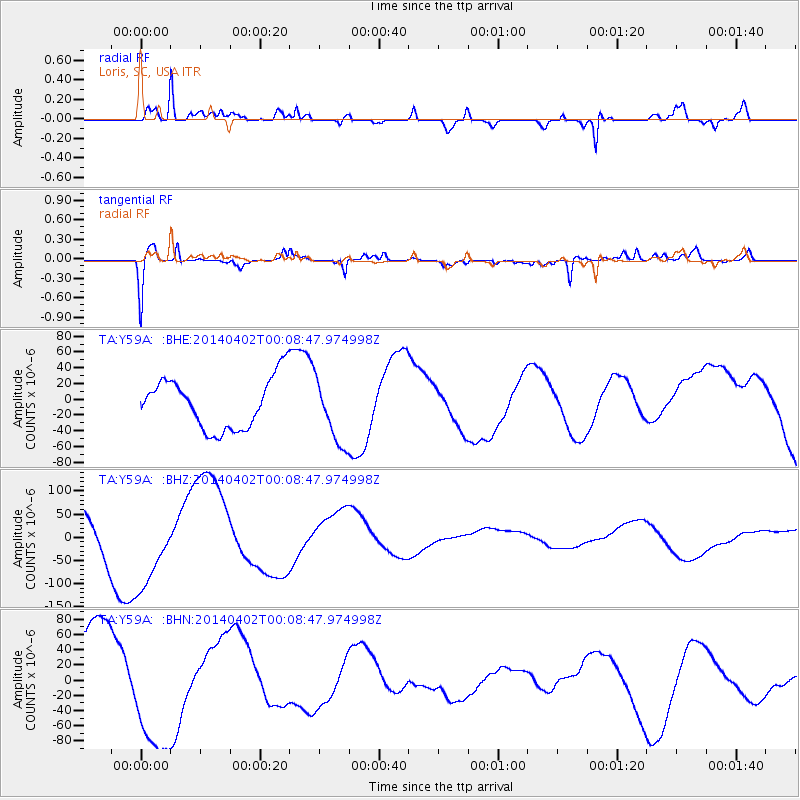
Y59A Loris, SC, USA - Earthquake Result Viewer
*The percent match for this event was below the threshold and hence no stack was calculated.
| Earthquake location: |
Near Coast Of Northern Chile |
| Earthquake latitude/longitude: |
-19.5/-70.2 |
| Earthquake time(UTC): |
2014/04/01 (091) 23:59:57 GMT |
| Earthquake Depth: |
22 km |
| Earthquake Magnitude: |
5.8 MB |
| Earthquake Catalog/Contributor: |
NEIC PDE/NEIC COMCAT |
|
| Network: |
TA USArray Transportable Network (new EarthScope stations) |
| Station: |
Y59A Loris, SC, USA |
| Lat/Lon: |
33.99 N/78.87 W |
| Elevation: |
2.0 m |
|
| Distance: |
53.8 deg |
| Az: |
351.035 deg |
| Baz: |
169.809 deg |
| Ray Param: |
$rayparam |
*The percent match for this event was below the threshold and hence was not used in the summary stack. |
|
| Radial Match: |
70.032455 % |
| Radial Bump: |
400 |
| Transverse Match: |
77.76398 % |
| Transverse Bump: |
400 |
| SOD ConfigId: |
626651 |
| Insert Time: |
2014-05-07 03:49:23.011 +0000 |
| GWidth: |
2.5 |
| Max Bumps: |
400 |
| Tol: |
0.001 |
|
Signal To Noise
| Channel | StoN | STA | LTA |
| TA:Y59A: :BHZ:20140402T00:08:47.974998Z | 1.9957514 | 9.539269E-5 | 4.779788E-5 |
| TA:Y59A: :BHN:20140402T00:08:47.974998Z | 1.5674787 | 8.19771E-5 | 5.2298703E-5 |
| TA:Y59A: :BHE:20140402T00:08:47.974998Z | 1.2848984 | 4.1163737E-5 | 3.203657E-5 |
| Arrivals |
| Ps | |
| PpPs | |
| PsPs/PpSs | |


