You are here: Home > Network List > US - United States National Seismic Network Stations List
> Station ELK Elko, Nevada, USA > Earthquake Result Viewer
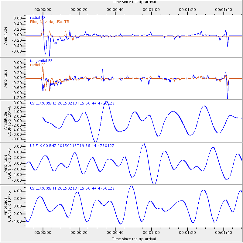
ELK Elko, Nevada, USA - Earthquake Result Viewer
*The percent match for this event was below the threshold and hence no stack was calculated.
| Earthquake location: |
Northern Mid-Atlantic Ridge |
| Earthquake latitude/longitude: |
52.7/-31.9 |
| Earthquake time(UTC): |
2015/02/13 (044) 19:47:42 GMT |
| Earthquake Depth: |
13 km |
| Earthquake Magnitude: |
4.8 mb |
| Earthquake Catalog/Contributor: |
ISC/ISC |
|
| Network: |
US United States National Seismic Network |
| Station: |
ELK Elko, Nevada, USA |
| Lat/Lon: |
40.74 N/115.24 W |
| Elevation: |
2210 m |
|
| Distance: |
55.3 deg |
| Az: |
293.327 deg |
| Baz: |
47.327 deg |
| Ray Param: |
$rayparam |
*The percent match for this event was below the threshold and hence was not used in the summary stack. |
|
| Radial Match: |
61.26579 % |
| Radial Bump: |
400 |
| Transverse Match: |
63.575653 % |
| Transverse Bump: |
400 |
| SOD ConfigId: |
7019011 |
| Insert Time: |
2019-04-16 19:50:56.572 +0000 |
| GWidth: |
2.5 |
| Max Bumps: |
400 |
| Tol: |
0.001 |
|
Signal To Noise
| Channel | StoN | STA | LTA |
| US:ELK:00:BHZ:20150213T19:56:44.475012Z | 1.2324469 | 2.0741622E-6 | 1.6829629E-6 |
| US:ELK:00:BH1:20150213T19:56:44.475012Z | 0.76588416 | 1.5499498E-6 | 2.0237392E-6 |
| US:ELK:00:BH2:20150213T19:56:44.475012Z | 3.0189497 | 6.505154E-6 | 2.154774E-6 |
| Arrivals |
| Ps | |
| PpPs | |
| PsPs/PpSs | |


