You are here: Home > Network List > PF - Volcanologic Network of Piton de Fournaise-OVPF Stations List
> Station HIM cratere Himiltrude > Earthquake Result Viewer
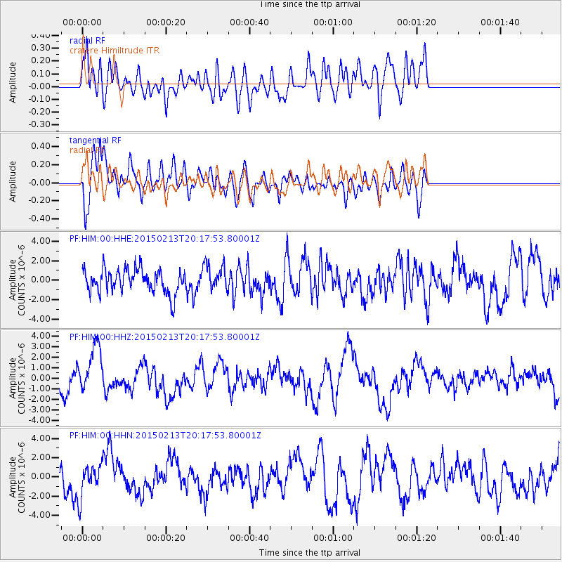
HIM cratere Himiltrude - Earthquake Result Viewer
*The percent match for this event was below the threshold and hence no stack was calculated.
| Earthquake location: |
Taiwan Region |
| Earthquake latitude/longitude: |
22.6/121.4 |
| Earthquake time(UTC): |
2015/02/13 (044) 20:06:31 GMT |
| Earthquake Depth: |
24 km |
| Earthquake Magnitude: |
6.2 MWW, 6.1 MWR, 6.3 MWC |
| Earthquake Catalog/Contributor: |
NEIC PDE/NEIC COMCAT |
|
| Network: |
PF Volcanologic Network of Piton de Fournaise-OVPF |
| Station: |
HIM cratere Himiltrude |
| Lat/Lon: |
21.21 S/55.72 E |
| Elevation: |
1958 m |
|
| Distance: |
77.5 deg |
| Az: |
240.601 deg |
| Baz: |
59.626 deg |
| Ray Param: |
$rayparam |
*The percent match for this event was below the threshold and hence was not used in the summary stack. |
|
| Radial Match: |
48.937916 % |
| Radial Bump: |
400 |
| Transverse Match: |
65.467705 % |
| Transverse Bump: |
400 |
| SOD ConfigId: |
7019011 |
| Insert Time: |
2019-04-16 19:56:25.720 +0000 |
| GWidth: |
2.5 |
| Max Bumps: |
400 |
| Tol: |
0.001 |
|
Signal To Noise
| Channel | StoN | STA | LTA |
| PF:HIM:00:HHZ:20150213T20:17:53.80001Z | 2.2841954 | 2.3413E-6 | 1.025E-6 |
| PF:HIM:00:HHN:20150213T20:17:53.80001Z | 0.98991156 | 1.7160592E-6 | 1.733548E-6 |
| PF:HIM:00:HHE:20150213T20:17:53.80001Z | 1.1145769 | 1.3696358E-6 | 1.2288392E-6 |
| Arrivals |
| Ps | |
| PpPs | |
| PsPs/PpSs | |


