You are here: Home > Network List > TA - USArray Transportable Network (new EarthScope stations) Stations List
> Station G47A Hillman, MI, USA > Earthquake Result Viewer
G47A Hillman, MI, USA - Earthquake Result Viewer
| Earthquake location: |
Near Coast Of Northern Chile |
| Earthquake latitude/longitude: |
-19.6/-70.5 |
| Earthquake time(UTC): |
2014/04/02 (092) 00:04:54 GMT |
| Earthquake Depth: |
34 km |
| Earthquake Magnitude: |
5.5 MB |
| Earthquake Catalog/Contributor: |
NEIC PDE/NEIC COMCAT |
|
| Network: |
TA USArray Transportable Network (new EarthScope stations) |
| Station: |
G47A Hillman, MI, USA |
| Lat/Lon: |
45.17 N/83.86 W |
| Elevation: |
239 m |
|
| Distance: |
65.6 deg |
| Az: |
349.663 deg |
| Baz: |
166.163 deg |
| Ray Param: |
0.05811575 |
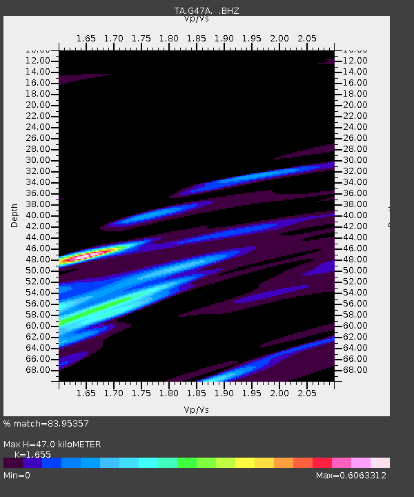
| Estimated Moho Depth: |
47.0 km |
| Estimated Crust Vp/Vs: |
1.65 |
| Assumed Crust Vp: |
6.483 km/s |
| Estimated Crust Vs: |
3.917 km/s |
| Estimated Crust Poisson's Ratio: |
0.21 |
|
| Radial Match: |
83.95357 % |
| Radial Bump: |
400 |
| Transverse Match: |
69.10538 % |
| Transverse Bump: |
400 |
| SOD ConfigId: |
626651 |
| Insert Time: |
2014-05-07 04:23:34.434 +0000 |
| GWidth: |
2.5 |
| Max Bumps: |
400 |
| Tol: |
0.001 |
|

Signal To Noise
| Channel | StoN | STA | LTA |
| TA:G47A: :BHZ:20140402T00:15:04.374988Z | 1.0277619 | 4.918944E-5 | 4.7860733E-5 |
| TA:G47A: :BHN:20140402T00:15:04.374988Z | 1.7671404 | 3.376513E-5 | 1.9107214E-5 |
| TA:G47A: :BHE:20140402T00:15:04.374988Z | 0.597434 | 2.6942955E-5 | 4.5097793E-5 |
| Arrivals |
| Ps | 5.0 SECOND |
| PpPs | 18 SECOND |
| PsPs/PpSs | 23 SECOND |


