You are here: Home > Network List > TA - USArray Transportable Network (new EarthScope stations) Stations List
> Station Q53A Leroy, WV, USA > Earthquake Result Viewer
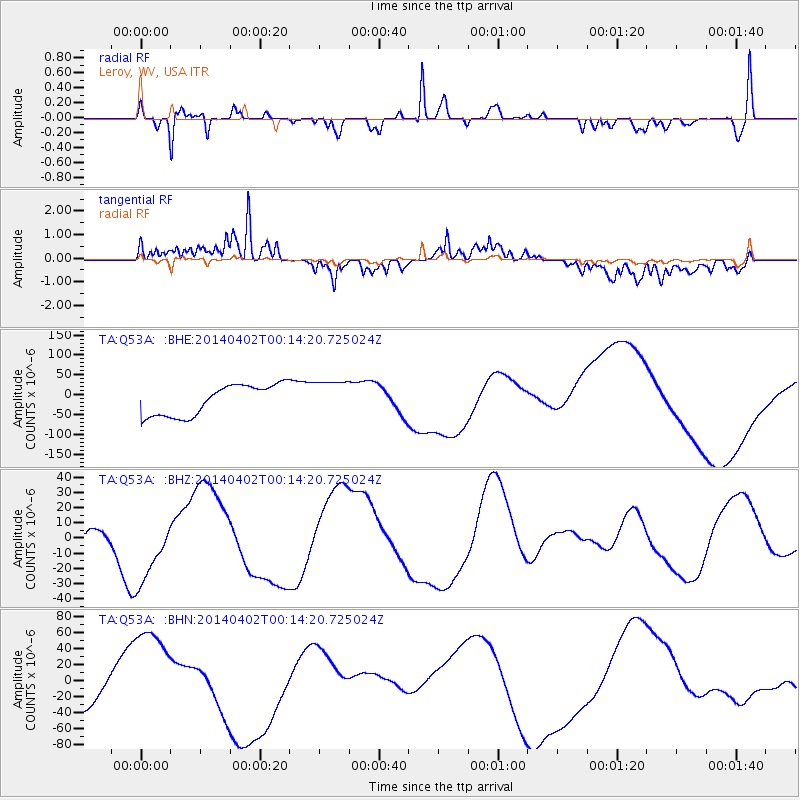
Q53A Leroy, WV, USA - Earthquake Result Viewer
*The percent match for this event was below the threshold and hence no stack was calculated.
| Earthquake location: |
Near Coast Of Northern Chile |
| Earthquake latitude/longitude: |
-19.6/-70.5 |
| Earthquake time(UTC): |
2014/04/02 (092) 00:04:54 GMT |
| Earthquake Depth: |
34 km |
| Earthquake Magnitude: |
5.5 MB |
| Earthquake Catalog/Contributor: |
NEIC PDE/NEIC COMCAT |
|
| Network: |
TA USArray Transportable Network (new EarthScope stations) |
| Station: |
Q53A Leroy, WV, USA |
| Lat/Lon: |
38.86 N/81.53 W |
| Elevation: |
310 m |
|
| Distance: |
59.1 deg |
| Az: |
349.973 deg |
| Baz: |
167.863 deg |
| Ray Param: |
$rayparam |
*The percent match for this event was below the threshold and hence was not used in the summary stack. |
|
| Radial Match: |
75.70636 % |
| Radial Bump: |
279 |
| Transverse Match: |
68.2756 % |
| Transverse Bump: |
400 |
| SOD ConfigId: |
626651 |
| Insert Time: |
2014-05-07 04:28:12.094 +0000 |
| GWidth: |
2.5 |
| Max Bumps: |
400 |
| Tol: |
0.001 |
|
Signal To Noise
| Channel | StoN | STA | LTA |
| TA:Q53A: :BHZ:20140402T00:14:20.725024Z | 1.5153143 | 2.159932E-5 | 1.4254019E-5 |
| TA:Q53A: :BHN:20140402T00:14:20.725024Z | 4.465524 | 6.376948E-5 | 1.4280402E-5 |
| TA:Q53A: :BHE:20140402T00:14:20.725024Z | 1.1653866 | 4.5365156E-5 | 3.892713E-5 |
| Arrivals |
| Ps | |
| PpPs | |
| PsPs/PpSs | |


