You are here: Home > Network List > II - Global Seismograph Network (GSN - IRIS/IDA) Stations List
> Station KAPI Kappang, Sulawesi, Indonesia > Earthquake Result Viewer
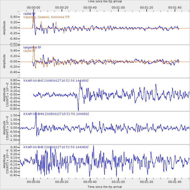
KAPI Kappang, Sulawesi, Indonesia - Earthquake Result Viewer
*The percent match for this event was below the threshold and hence no stack was calculated.
| Earthquake location: |
Southeast Of Loyalty Islands |
| Earthquake latitude/longitude: |
-21.7/170.5 |
| Earthquake time(UTC): |
2008/09/12 (256) 16:44:30 GMT |
| Earthquake Depth: |
116 km |
| Earthquake Magnitude: |
5.8 MW, 5.4 MB, 5.8 MW |
| Earthquake Catalog/Contributor: |
WHDF/NEIC |
|
| Network: |
II Global Seismograph Network (GSN - IRIS/IDA) |
| Station: |
KAPI Kappang, Sulawesi, Indonesia |
| Lat/Lon: |
5.01 S/119.75 E |
| Elevation: |
300 m |
|
| Distance: |
51.8 deg |
| Az: |
281.074 deg |
| Baz: |
113.618 deg |
| Ray Param: |
$rayparam |
*The percent match for this event was below the threshold and hence was not used in the summary stack. |
|
| Radial Match: |
79.4253 % |
| Radial Bump: |
400 |
| Transverse Match: |
64.9227 % |
| Transverse Bump: |
400 |
| SOD ConfigId: |
2504 |
| Insert Time: |
2010-03-01 21:27:40.100 +0000 |
| GWidth: |
2.5 |
| Max Bumps: |
400 |
| Tol: |
0.001 |
|
Signal To Noise
| Channel | StoN | STA | LTA |
| II:KAPI:00:BHN:20080912T16:52:56.144989Z | 7.7421656 | 6.246963E-7 | 8.068754E-8 |
| II:KAPI:00:BHE:20080912T16:52:56.144989Z | 2.0121572 | 1.2884259E-7 | 6.403207E-8 |
| II:KAPI:00:BHZ:20080912T16:52:56.144989Z | 6.478575 | 3.8410352E-7 | 5.928827E-8 |
| Arrivals |
| Ps | |
| PpPs | |
| PsPs/PpSs | |


