You are here: Home > Network List > TA - USArray Transportable Network (new EarthScope stations) Stations List
> Station Y12C Blythe, CA, USA > Earthquake Result Viewer
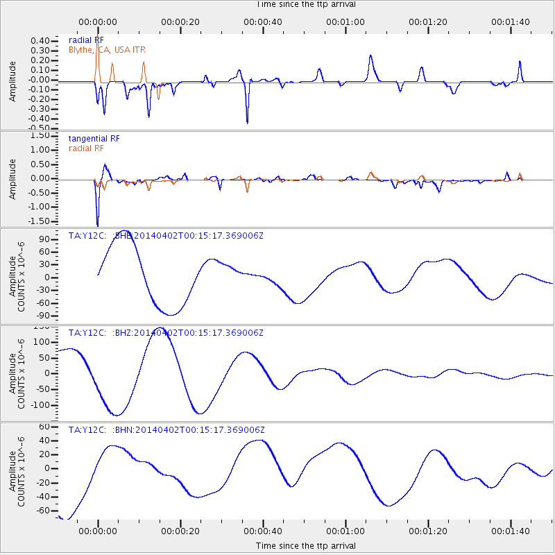
Y12C Blythe, CA, USA - Earthquake Result Viewer
*The percent match for this event was below the threshold and hence no stack was calculated.
| Earthquake location: |
Near Coast Of Northern Chile |
| Earthquake latitude/longitude: |
-19.6/-70.5 |
| Earthquake time(UTC): |
2014/04/02 (092) 00:04:54 GMT |
| Earthquake Depth: |
34 km |
| Earthquake Magnitude: |
5.5 MB |
| Earthquake Catalog/Contributor: |
NEIC PDE/NEIC COMCAT |
|
| Network: |
TA USArray Transportable Network (new EarthScope stations) |
| Station: |
Y12C Blythe, CA, USA |
| Lat/Lon: |
33.75 N/114.52 W |
| Elevation: |
196 m |
|
| Distance: |
67.6 deg |
| Az: |
321.235 deg |
| Baz: |
134.886 deg |
| Ray Param: |
$rayparam |
*The percent match for this event was below the threshold and hence was not used in the summary stack. |
|
| Radial Match: |
65.602356 % |
| Radial Bump: |
359 |
| Transverse Match: |
54.15892 % |
| Transverse Bump: |
400 |
| SOD ConfigId: |
626651 |
| Insert Time: |
2014-05-07 04:30:09.054 +0000 |
| GWidth: |
2.5 |
| Max Bumps: |
400 |
| Tol: |
0.001 |
|
Signal To Noise
| Channel | StoN | STA | LTA |
| TA:Y12C: :BHZ:20140402T00:15:17.369006Z | 2.0523407 | 1.0119371E-4 | 4.9306487E-5 |
| TA:Y12C: :BHN:20140402T00:15:17.369006Z | 0.39246306 | 2.0249654E-5 | 5.1596333E-5 |
| TA:Y12C: :BHE:20140402T00:15:17.369006Z | 0.34444875 | 2.4319534E-5 | 7.060421E-5 |
| Arrivals |
| Ps | |
| PpPs | |
| PsPs/PpSs | |


