You are here: Home > Network List > II - Global Seismograph Network (GSN - IRIS/IDA) Stations List
> Station KAPI Kappang, Sulawesi, Indonesia > Earthquake Result Viewer
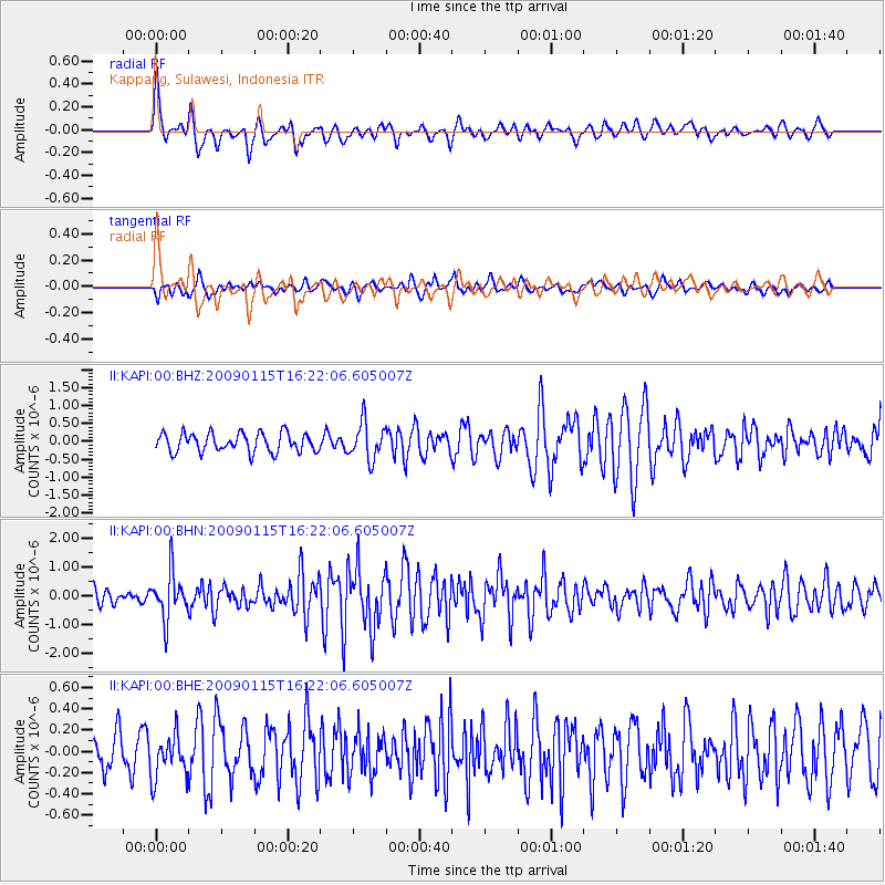
KAPI Kappang, Sulawesi, Indonesia - Earthquake Result Viewer
*The percent match for this event was below the threshold and hence no stack was calculated.
| Earthquake location: |
Solomon Islands |
| Earthquake latitude/longitude: |
-10.3/161.2 |
| Earthquake time(UTC): |
2009/01/15 (015) 16:15:01 GMT |
| Earthquake Depth: |
114 km |
| Earthquake Magnitude: |
5.6 MB, 5.7 MW, 5.7 MW |
| Earthquake Catalog/Contributor: |
WHDF/NEIC |
|
| Network: |
II Global Seismograph Network (GSN - IRIS/IDA) |
| Station: |
KAPI Kappang, Sulawesi, Indonesia |
| Lat/Lon: |
5.01 S/119.75 E |
| Elevation: |
300 m |
|
| Distance: |
41.4 deg |
| Az: |
274.13 deg |
| Baz: |
99.885 deg |
| Ray Param: |
$rayparam |
*The percent match for this event was below the threshold and hence was not used in the summary stack. |
|
| Radial Match: |
77.08648 % |
| Radial Bump: |
400 |
| Transverse Match: |
50.4313 % |
| Transverse Bump: |
400 |
| SOD ConfigId: |
2834 |
| Insert Time: |
2010-03-01 21:27:48.933 +0000 |
| GWidth: |
2.5 |
| Max Bumps: |
400 |
| Tol: |
0.001 |
|
Signal To Noise
| Channel | StoN | STA | LTA |
| II:KAPI:00:BHN:20090115T16:22:06.605007Z | 3.5365212 | 8.0063506E-7 | 2.2639057E-7 |
| II:KAPI:00:BHE:20090115T16:22:06.605007Z | 1.0739975 | 2.059799E-7 | 1.9178806E-7 |
| II:KAPI:00:BHZ:20090115T16:22:06.605007Z | 1.9693544 | 5.139363E-7 | 2.6096689E-7 |
| Arrivals |
| Ps | |
| PpPs | |
| PsPs/PpSs | |


